Students of ICSE Class 10 should refer to Climate of South Asia ICSE Class 10 Geography Questions below which have come in past board exams. You should always go through questions that have come in previous years. This will help you to understand the pattern of questions in ICSE Class 10 Geography and prepare accordingly. This will help you to get better marks in ICSE Class 10 Board Exams
ICSE Class 10 Geography Climate of South Asia Important Questions
Students should learn the important questions and answers given below for Chapter Climate of South Asia in Geography for ICSE Class 10. These board questions are expected to come in the upcoming exams. Students of ICSE Class 10th should go through the Important questions and answers ICSE Class 10 Geography which will help them to get more marks in exams.
Board Exam Questions Climate of South Asia ICSE Class 10 Geography
Climate of South Asia ICSE Class 10 Geography Important Questions
One Word Question and Answer
a. One region which gets rainfall due to the western disturbances.
Ans.
North-west India (Punjab)
b. A hot local wind that blows in summer in the northern plains.
Ans.
Loo
c. A region in India which gets most of its rainfall during winter.
Ans.
Tamil Nadu
d. A place in India which receives the heaviest rainfall in the world.
Ans.
Mawsynram
e. A region which receives very little or no rainfall due to the south west monsoon season.
Ans.
Tamil Nadu /Coromandal coast
f. Winds that bring rain to the coast of Tamil Nadu.
Ans.
North-east monsoon
g. Devastating storm occurring in West Bengal in summer.
Ans.
Kalbaisakhi
h. State in India which receives ‘mango showers’.
Ans.
Kerala
i. Area from where the ‘Western disturbances’ originate.
Ans.
Mediterranean Sea
j. Two branches of the south west monsoon.
Ans.
Arabian Sea Branch, Bay of Bengal Branch
k. State where the monsoon arrives first
Ans.
Kerala
l. Place where monsoon arrives first
Ans.
Kanyakumari
m. Area of intense low pressure in the northern plains in summer
Ans.
Low Pressure Trough
n. Two states in India frequently struck by tropical cyclones
Ans.
West Bengal and Orissa
o. Months in which cyclones originate in the Andaman Sea.
Ans.
October and November
What do you understand by the following?
a. Climatic divide
Ans. A bold relief feature which has two different types of climates on its either side is called a climatic divide.
b. Annual range of temperature
Ans. The difference between highest monthly mean temperature and the lowest monthly mean temperature is called annual range of temperature. In other words, it is the difference in mean temperature of the hottest month subtracted by the mean temperature of the coldest month. Annual Range of temperature = Mean temperature of hottest month – mean temperature of the coldest month
c. Moderating influence of the sea
Ans. In coastal areas, land is in contact with the sea. Hence, the heat absorbed by the land in the day is transferred to the sea. Vice-versa, the heat absorbed by the sea is transferred back to the land in the night. As a result, places in coastal areas do not become very hot in the day or very cold in the night. This phenomenon is called moderating influence of the sea.
d. Equable climate
Ans. If the annual range of temperature is very less (<5° C), a place is said to have equable climate mostly found in the coastal areas.
e. Extreme climate
Ans. the annual range of temperature is quite high (>20° C), a place is said to have extreme climate normally found in interior areas. Also known as continental climate.
f. Loo
Loo is a local name given to hot and dry winds which blow into the low pressure trough created in the northern plains in summer.
g. Kal Baisakhi
Ans. Kalbaisakhi (Calamity in the month of harvest or Baisakh) is the name given to violent storms hitting the coast of West Bengal in April and May. These cause widespread destruction.
h. Mango Showers
Pre-monsoon showers in Kerala that help in ripening of mangoes are known as mango showers.
i. Western disturbances
Ans. Western Disturbance is the term used in India, Pakistan, Afghanistan and Nepal to describe cyclones which bring sudden winter rain and snow to the north western parts of the Indian subcontinent. This precipitation pattern is driven by the meeting of the warm Westerlies with the cool dry NE monsoons. The moisture in these storms usually originates over the Mediterranean Sea.
j. Retreating monsoon
Ans. After September 23, the sun moves south of the equator due to which India becomes cooler. The low pressure existing over the Indian sub-continent is gradually replaced by high pressure. As a result, the monsoon decreases in intensity. The methodical withdrawal of the south west monsoon from the Indian sub-continent is called retreating monsoon or retreating south-west monsoon.
k. Orographic Rainfall
Ans. When a cloud is encountered by a mountain, it rises on the windward side. The temperature towards the top is less on account of altitude. At a lesser temperature, air loses its moisture carrying capacity and the excess moisture is given off as rainfall. This phenomenon is called orographic or relief rainfall.
l. North East Monsoon
Ans. In winter, winds blow from land to sea. In the Indian sub-continent, winds blow from India into the Indian Ocean from north-east to south-west in accordance with Ferrell’s Law. This seems to be the return of the south-west monsoon as is therefore named as north east monsoon. The phenomenon is also sometimes stated as reversal of monsoons.
m. October Heat
Ans. In the month of October due to high temperature and humidity the weather becomes oppressive and called October heat. The retreat of the monsoon is marked by clear skies and rise in temperature but the land is still moist, so it becomes very oppressive – hot and moist.
State three characteristics of the monsoon kind of climate.
Ans. Following are the three characteristics of the monsoon kind of climate.
a. There is a distinct rainy season from June to September
b. Rainfall occurs due to seasonal winds called monsoons.
c. Rainfall is sudden, unpredictable and uncertain.
Why is India sometimes said to have a ‘sub-tropical’ kind of climate?
Ans. The Tropic of Cancer divides India into two equal halves. The southern half is completely in the Torrid Zone while the northern Half is completely in the Temperate Zone. Yet, the climate of places in both the northern and southern region is not very different from each other on account of the Himalayas and the monsoons. It is for this reason that India is sometimes said to have a ‘sub-tropical’ kind of climate which means that the typical tropical kind of climate has been modified by the monsoons.
List three reasons for the extremes prevalent in the climate of India.
Ans. Three reasons for the extremes of climate prevalent in India are
a. Physical Features (rainfall)
b. Distance from the Sea (annual range of temperature)
c. Altitude (annual mean temperature)
List the factors affecting the climate of India.
Ans. Factors affecting climate of India are
Major factors
1. Latitude
2. Physical features like Himalayas, Arakan Yoma Range, Aravallis, Western Ghats etc.
3. Distance from the sea
4. Altitude
Minor Factors
1. Western Disturbances
2. Conditions surrounding India
3. Jet Streams
What is the influence of the following on the climate of India?
Ans. a. The Himalayas
b. The Arakan Yoma Range
c. The Aravallis
The Himalayas affect the climate of India in the following ways.
a. They prevent cold winds coming from the north.
b. They force the monsoons to shed their moisture over India.
c. They also cause the western disturbances to cause rainfall in north-west India and deflect them into the Bay of Bengal making the north-east monsoon stronger.
Name the months of the following.
Ans. a. Cold weather season – December, January and February
b. Hot weather season – March, April and May
c. South West Monsoon season – June, July, August and September
d. Retreating monsoon season – October and November
Give reasons for the following.
a. Thiruvananthapuram is warmer than Agra in December.
Ans. Thiruvananthapuram is closer to the equator than Agra. For this reason, it is warmer than Agra in December, when the sun rays are directly overhead in the southern hemisphere.
b. Deccan plateau is cooler than the northern plains in summer.
Ans. The Deccan plateau is higher than the northern plains. As altitude increases, temperature decreases. Hence, it is cooler than the northern plains in summer.
c. The south west monsoon approaches Uttar Pradesh from the east.
Ans. The winds which bring rainfall to Uttar Pradesh are the Bay of Bengal Branch of the south-west monsoons which upon deflection by the Arakan Yoma Range, travels north-westward into India. So, these winds would approach Uttar Pradesh from the east.
d. Delhi has a higher annual range of temperature than Mumbai.
Ans. Delhi is in the interior of India where the moderating influence of the sea is absent. Mumbai on the other hand lies closer to the sea. Hence, the annual range of temperature in Delhi is more than the annual range of temperature in Mumbai.
e. Shillong experiences lesser rainfall than Mawsynram.
Ans. Mawsynram lies in the funnel shaped depression caused by the Khasi range in Meghalaya. The Bay of Bengal branch of monsoons is trapped in it, causing heavy rainfall. Shillong, on the other hand, lies on the leeward side of the Khasi hills and gets lesser rainfall.
f. Punjab gets winter rainfall
Ans. Punjab lies on the foothills of the Himalayas. The western disturbances originating over the Mediterranean Sea in winter travel eastward towards India where are forced to shed their moisture in Punjab. Therefore, Punjab receives rainfall in the winter.
g. Bikaner has a high diurnal range of temperature.
Ans. Bikaner lies on the edge of the Thar Desert. The land has little vegetation cover so it absorbs heat quickly in the day and loses it quickly in the night. For this reason, it is very hot during the day and quite cold during the night. Hence, Bikaner is said to have a high diurnal range of temperature.
h. Thar desert gets little or no rainfall
Ans. The Aravallis are parallel to the direction of the Arabia Sea branch of the South West Monsoon. Hence there is no rainfall in Rajasthan due to this branch. On the other hand, the Aravallis block the Bay of Bengal branch towards their east which is why there is little or no rainfall in the western part of Rajasthan where the Thar Desert lies.
i. Western Rajasthan is the region where the pressure is lowest in May.
Ans. Rajasthan is away from the moderating influence of the sea. As a result, the monthly mean temperature is very high in May and June. The hot air rises and creates a regime of extremely low pressure.
j. In spite of extremely low pressure over the northern plains in summer, monsoon winds are not drawn into the Indian sub-continent.
Ans. As the peninsular plateau is at an altitude, the summer temperatures are lower than in the northern plains. This creates an area of slightly higher pressure over the peninsular plateau which does not allow the monsoons to come over India.
k. The monsoon winds in India are divided into two components.
Ans. Due to the triangular shape of the Indian peninsula and the fact that the western part of the peninsular tip is higher, the south-west monsoon winds are divided into two components – the Arabian Sea branch and the Bay of Bengal branch.
l. South East Trade winds are attracted into India.
Ans. In June, India becomes extremely hot which is why the entire Indian subcontinent becomes a region of extremely low pressure. This causes the South East Trade Winds (which usually blow only till the equator) to cross the equator, be deflected due to Coriolis force and enter India.
m. Tamil Nadu gets winter rainfall.
Ans. Tamil Nadu lies on the leeward side of the Western Ghats because of which it does not receive any rainfall in summer due to the south-west monsoon. However, in winter, the north-east monsoon picks up moisture from the Bay of Bengal and sheds rainfall in Tamil Nadu.
n. Mumbai receives more rainfall than Chennai.
Ans. Mumbai lies on the windward side of the Western Ghats where the south-west monsoons strike first and are forced to shed their moisture. Chennai lie on the east which does not receive any rainfall due to the south-west monsoon. The rainfall in winter is substantially less than Mumbai.
o. Mangalore and Chennai are on the same latitude yet both these cities receive rainfall in different months.
Ans. Mangalore gets rainfall between June to September because it is on the windward side of the Western Ghats. It receives rainfall from the south-west monsoon winds. Chennai which lies in the rain-shadow area of the Western Ghats gets a little rainfall from the south-west monsoon winds. It gets rainfall from the north-east winds in winter because Chennai faces the north-east monsoon. It is situated on the windward side of the Eastern Ghats.
p. North Eastern Part of Kashmir receives practically no rainfall.
Ans.North Eastern Kashmir lies on the other side of the mighty Himalayas. None of the branches of the south-west monsoon are able to cross them and as a result, north-east Kashmir receives practically no rainfall.
q. Patna gets heavier rainfall than Agra.
Ans. Patna is in the middle Ganga valley while Agra is in the upper Ganga Valley. By the time the Bay of Bengal branch of the south-west monsoon reaches Agra, it has lost much of its moisture and therefore, Agra receives lesser rainfall than Patna.
r. Mawsynram receives the highest rainfall in the world.
Ans. Mawsynram lies in the funnel shaped depression caused by the Khasi range in Meghalaya. The Bay of Bengal branch of monsoons is trapped in it and causes heavy rainfall.
s. The monsoon rain is unevenly distributed over India.
Ans. Because of the uneven relief of India due to the presence of a number of hill ranges, the monsoon is not able to shed its moisture evenly over India. Windward sides receive more rainfall and leeward sides receive less rainfall.
t. Most of the rainfall of the Indian sub-continent is received only in four months of the year.
Ans. In spite of being in the Trade Wind belt, India is unaffected by the Trade Winds due to the presence of the Himalayas. Instead, India receives rainfall due to the monsoon winds which are seasonal in nature and are on-shore winds only in four months – June to September. For the remaining part of the year, they are off-shore winds and do not bring rainfall.
u. The Indo-Gangetic plain gets some rain during December and January.
Ans. The western part of the Indo-Gangetic Plains receives rainfall due to the western disturbances originating over the Mediterranean Sea in December and January.
v. Nainital is cooler than Agra.
Ans. Nainital is cooler than Agra because Nainital is at a higher altitude (2700 m) than Agra
w. The Coromandel Coast gets most of its rain in the winter season.
Ans. Coromandel Coast lies on the leeward side of the Western Ghats because of which it does not receive any rainfall in summer due to the south-west monsoon. However, in winter, the north-east monsoon picks up moisture from the Bay of Bengal and sheds rainfall on the Coromandel Coast.
Question. Why do the monsoons retreat?
Ans. After the monsoons have shed their moisture over India, the land becomes cool. In addition, the sun now moves from the equator towards the Tropic of Capricorn. India becomes cooler and the initial low pressure which existed over the Indian sub-continent now changes to high pressure. As a result, the intensity of the south-west monsoons decreases and they follow a systematic withdrawal from India. The south-west monsoon then called ‘Retreating South West Monsoon’.
Question. Explain the mechanism of the westerly depressions.
Ans. In winter, the sub-tropical high pressure belt moves over the Mediterranean Sea, which is why the Westerlies blow in the form of shallow cyclonic depressions from the Mediterranean Sea northeastward into Europe. The north-western part of the Indian sub-continent lies in the Westerlies wind belt. These western disturbances arrive in this region and cause winter rainfall.
Question. State the characteristics of the following.
a. The advancing south west monsoon season.
Ans. Following are the characteristics of the advancing south-west monsoon season.
1. They occur from June to September.
2. They give rainfall to almost entire India.
3. They are very strong and moisture laden.
b. The retreating south west monsoon season.
Ans. Following are the characteristics of the retreating south-west monsoon season.
1. They occur in October and November.
2. They give rainfall only to peninsular India.
3. They are not strong and contain little moisture
Question. List three differences between
a. The Retreating south west monsoons and the North East monsoons.
Ans. Retreating south west monsoon North East monsoon Months October and November December, January and
February Direction From South West to North East (sea to land) From north-east to southwest (land to sea) Rainfall West Coast East Coast
b. The Arabian Sean branch and the Bay of Bengal Branch
Ans. Arabian Sea branch Bay of Bengal Branch Source of moisture Arabian Sea Bay of Bengal Direction South west to north east South-east to north-west Rainfall Southern &Western India Eastern and Central India
c. Equable and Extreme climate
Ans. Equable Climate Extreme climate
1 Moderating influence of sea present Moderating influence of sea absent
2 Characteristic of coastal areas Characteristic of interior regions
3 Annual Range of Temperature is low Annual Range of temperature is high
d. Precipitation and Rainfall
Precipitation Rainfall
Ans. 1 May occur in many forms such as snow, hail, sleet, etc. Occurs as descending droplets of water
2 Occurs in specific areas only Occurs almost everywhere
3 Cloud formation not necessary in some cases Cloud formation essential
State the economic importance of the following.
a. Relief rain in Tamil Nadu
Ans. Relief rainfall in Tamil Nadu (Palni and Shevaroy hills) is beneficial for the millets and rice crops.
b. Cyclonic Rainfall in Punjab
Ans. Cyclonic rainfall in Punjab during winter is highly useful for rabi crops in Punjab, Haryana and Western Uttar Pradesh.
c. Mango Showers in Kerala
Ans. Mango showers on the Kerala coast are early Pre-monsoon showers before the south-west monsoons which are good for the mango trees.
Question. State the salient features of the monsoon rainfall in India.
Ans. Following are the salient features of the monsoon rainfall in India.
a. It occurs in mostly in summer
b. It is erratic and unpredictable.
c. It is very unevenly distributed
d. The rainfall is mainly orographic (relief) in nature.
e. Rainfall also occurs due to cyclones and convection currents.
Study the climate data given below and answer the questions that follow.

Question. Calculate the annual rainfall for Station A.
Ans. The annual rainfall for Station A is 67.6 cm. it is calculated by adding the rainfall received in a year.
Question. What is the annual range of temperature at Station B?
Ans. The annual range of temperature at Station B is 5.6 °C. it is the difference between the highest and the lowest temperatures in a year.
Question. In which hemisphere do you think Station A lies?
Ans. Station A lies in the Northern Hemisphere. This is because it has summers in June and winter in December.
Study the climatic data given below and answer the questions that follow:
Question. Which of these Stations has an equable climate?
Ans. Station B has an equable climate because the annual range of temperature is small (5.6° C). Summers are not very hot and winters are not very cold.
Question. Name two areas which get more than 200 cm of rainfall in India.
Answer: The windward side of the Western Ghats, southern slopes of Eastern
Himalayas, Assam, Arunachal Pradesh and West Bengal.
Question. Which winds are responsible for the rainfall experienced over the greater part of India?
Answer: South West monsoon winds are responsible for the rainfall experienced over the greater part of India.
Question. State the benefits that are derived from the local winds that blow in summer in the following areas: (a) Kerala (b) West Bengal
Answer: (i) Kerala : ‘Mango showers’ important for mango, tea and coffee plants.
(ii) West Bengal : Kalbaisakhi – strong winds which are beneficial for growing jute and rice in West Bengal.
Question. What is the cause of winter showers in Western Uttar Pradesh and Punjab?
Answer: Western disturbances originating from Mediterranean sea cause winter showers in Western Uttar Pradesh and Punjab.
Question. How are the sources of rainfall in the northwest part of India different from the rainfall experienced on the coastal areas of Eastern India in winter?
Answer: Northwest part of India gets rainfall in winter from western disturbances whereas the coastal area of Eastern India receives rainfall in winter from
Northeast monsoon.
Question. Explain the term ‘October Heat’.
Answer: October is a transition period between hot rainy season and cold dry season. During this period, the sky is cloudless and the temperature is high. This sultry and oppressive weather is called ‘October Heat.’
Question. Why does India have Monsoon type of climate?
Answer: India has a tropical Monsoon type of climate because India lies in the tropical belt and its climate is influenced by the monsoon winds which are
largely confined to the Tropics, i.e., between 20º N and 20º S.
Question. What is ‘Diurnal Range of Temperature’?
Answer: The difference between the highest and the lowest temperature of a place on a given day is called its ‘Diurnal range of temperature’.
Question. Name the type of climate prevailing over India. Mention any two factors responsible for it.
Answer: Tropical Monsoon
Two factors are
(i) Himalayas which act as a climate divide.
(ii) Monsoon winds which bring rainfall to Indian subcontinent.
Question. What is meant by the season of ‘Retreating Monsoon’? Name the months in which this rain is experienced.
Answer: (i) ‘Retreating Monsoon’ refers to the period of withdrawal of south-west monsoons. This is due to the gradual development of high pressure over the Ganga Plains.
(ii) This is experienced during the months of October and November.
Question. What is the economic importance of the following :
(a) Kalbaisakhi in West Bengal and Assam.
Answer: Rainfall from Kalbaisakhi is beneficial for growing rice and jute in West Bengal and tea in Assam.
(b) Mango showers in Kerala and Karnataka.
Answer: It is important for mango, tea and coffee plants in Kerala and helps in early ripening of mango crop in Karnataka.
(c) Cyclonic rainfall in Punjab.
Answer: It is beneficial for rabi crops.
(d) Relief rainfall on the Coromandel Coast.
Answer: It is good for rice cultivation.
Question. Briefly explain the role of the Himalayas in determining the climate of India during :
(a) The hot weather season.
Answer: The Himalayas are high altitude areas and are thus cooler than the other parts of India due to their altitude.
(b) The southwest monsoon season.
Answer: The Himalayas prevent the southwest monsoon winds from leaving India and thus these winds shed off their moisture on the Indian side whereas
Tibet remains a rainshadow region.
(c) The cold weather season.
Answer: The Himalayas form a climatic barrier separating the Indian sub-continent from the rest of Asia by preventing cold Siberian winds from entering the Indian region.
Question. Which state that has the longest rainy season by South West Monsoons? Give a reason for your answer.
Answer: (i) The state that has the longest South West Monsoon season is Kerala.
(ii) Kerala is situated at the southern-most part of peninsular India in the west where the Arabian sea branch of the advancing South West Monsoon touches the shores of India first.
(iii) On the other hand, since it is the southernmost state, even the retreating south west monsoon winds leave the state of Kerala last, thus making Kerala the state having longest South West monsoon season.
Question. What are known as ‘Jet Streams’? What are the two types of Jet Streams?
Answer: Jet streams are relatively narrow bands of strong air currents blowing in the upper layer of the atmosphere. They help the western disturbances to
enter into India. They also decide the arrival and departure of Monsoons.
The two types of Jet streams are
(i) Westerly Jet-streams that prevail over North Indian plains during winter months.
(ii) Easterly Jet-streams that cause tropical depressions in the tropical zone in the east.
Question. State two differences between the rainfalls that occur from June to September and that from December to February in North India.
Answer: (i) The rainfall caused during June to September in North India is caused by the South West Monsoon Winds. These are onshore winds which on
being obstructed by the Himalayas, result in heavy rainfall.
(ii) The rainfall caused during December – February in North India is caused by the Western Disturbances. These are temperate cyclones that originate in the Mediterranean Sea and travel towards India resulting in moderate rainfall.
Question. What is the direction of the summer monsoon ? Why ?
Answer: (i) South West.
(ii) The intense heat that prevails over India causes the development of low pressure over the northern plains. It attracts the moisture bearing South East Trade winds from the southern hemisphere.
(iii) After crossing the equator they are deflected to the right and blow over India as the south west monsoon winds.
Question. ‘Rainfall in India is orographic in nature.’ Give an example with reference to the distribution of rainfall and the effect of relief on its distribution.
Answer: (i) Relief plays a very important role in the distribution of rainfall in India.
(ii) The windward slopes of the Western Ghats obstruct the moist winds from the sea and cause heavy rainfall. While the leeward slopes remain dry.
Question. Mumbai is warmer than Kanpur in December.
Answer: Mumbai is warmer than Kanpur in December because,
(i) Kanpur has continental type of climate. i.e. it has very high temperature in summer and low temperature in winter.
(ii) Whereas coastal areas like Mumbai has moderating influence of land and sea breezes, hence it has Maritime climate. Therefore it does not experience very high temperature in summer and very low temperature in winter.
Question. The Northern Plains of India have a Continental type of climate.
Answer: The Northern Plains of India have a Continental type of climate, because northern plains do not have moderating influence of land breezes and sea breezes.
Question. Central Maharashtra receives little rainfall.
Answer: Central Maharashtra receives little rainfall because Central Maharashtra falls under the rain shadow area of Western Ghats.
Question. The monsoon rain is unevenly distributed over India.
Answer: (i) The monsoon rain is unevenly distributed over India because most parts of India receives relief rainfall, therefore windward sides always receive more rainfall than leeward side.
(ii) As well as some places like Aravalli, Coromandel coast lie parallel to south west monsoon winds. Therefore not able to obstruct these wind and receive very little rainfall.
Question. Excessive cold is experienced in north India during winter season.
Answer: In India nothern part have continental type of climate which is characterised by high temperature in summer and very low temperature in winter.
Question. Most of India remains dry during North-East Monsoon. OR The North East Monsoons bring almost no rain to most of India.
Answer: (i) Most of India remains dry during winters because it comes under the influence of the North-East monsoon winds which come from land and are thus dry winds.
(ii) When these winds pass over Bay of Bengal they collect moisture and give rainfall to Coromondel coast.
Question. Mangalore is not cold even in the month of December.
Answer: Mangalore lies in coastal area. Therefore its climate is moderated by land breezes and sea breezes. It does not experience extreme climate. Hence
Mangalore is not cold even in the month of December.
Question. Even in summer Shimla is cooler than Delhi.
Answer: Shimla l ies on a higher alti tude than Delhi . As altitude increases temperature decreases and thus Shimla is cooler than Delhi.
Question. The northern plains of India do not freeze in winter.
Answer: Due to Himalayas in the north the cold Siberian winds cannot enter India and thus the Northern plains do not freeze in the winter.
Question. The Summer Monsoon winds blows over the Arabian Sea from the South West.
Answer: (i) A high pressure gradient builds up between the hot North India with intense low pressure and cooler water bodies surrounding it with high pressure.
(ii) The low pressure area attracts the South-East trade winds blowing in the Southern hemisphere. After crossing the equator these winds are deflected towards the Indian Sub-continent as South-West monsoon winds which blow over Arabian Sea.
Question. Thar is a desert.
Answer: (i) The Arabian sea branch of South-West monsoon runs parallel to the Aravalli which does not offer any obstruction.
(ii) As a result Thar desert, located in the west of Aravalli, receives no rain. (iii) The moisture laden winds passing over Thar desert do not saturate as the heat in the desert region increases their capacity to hold moisture. So, Thar receives no rainfall.
Question. The Konkan coast experiences orographic rainfall.
Answer: (i) Orographic rainfall is mainly caused by the presence of a relief barrier.
(ii) The Konkan coast comprises of a part of the Western Ghats which obstructs the onshore Arabian Sea branch of the South West monsoon winds. This causes heavy rainfall on the western slopes of the Western Ghats which comprises the windward side of the Konkan coast.
(iii) While the eastern slopes receive less rainfall resulting in a rain shadow area. Hence the Konkan coast receives orographic rainfall due to the influence of the Western Ghats.
Question. The city of Kanpur in Uttar Pradesh has a higher range of temperature than that of Chennai in Tamil Nadu.
Answer: (i) Kanpur has an interior location while Chennai has a coastal location.
(ii) The areas in the interior of the country have an extreme type of climate resulting in high annual range of temperature while the coastal areas
have a moderate climate.
(iii) This is mainly due to the influence of land and sea breeze caused by differential heating and cooling of land and sea.
Question. The coastal areas of India do not experience a significant variation in temperature between summer and winter months. OR
Coastal areas have maritime climate.
Answer: The coastal areas of India do not experience a significant variation in temperature between summer and winter months due to the effect of land
and sea breeze caused by differential rate of heating and cooling of the land and sea which results in an equable and moderate climatic conditions.
Question. The annual rainfall in Rajasthan is less than 25 cm.
Answer: (i) The Arabian sea branch of the South West Monsoon which blows towards the Gujarat coast goes unhindered towards the Himalayas. The Aravalli
range lie parallel to the winds and offer no obstacle to the winds. Rajasthan, therefore, remain dry.
(ii) The Bay of Bengal branch which blows from the east sheds its rain on the way and gets dry by the time it reaches the west.
(iii) Rajasthan also lies in the rain shadow of the Aravalli range. Hence Rajasthan gets little rain, overall about 25 cm.
Question. The mango showers are beneficial local winds.
Answer: Mango showers are local winds which bring rain to Kerala in the month of May. It is good for the growth of mangoes, tea and coffee plants.
Question. The latitudinal extent of India is responsible for the variation in the climatic conditions which prevail in the country.
Answer: (i) The Northern plains lie to north of the Tropic of Cancer in the Temperate Zone. The winters are much colder.
(ii) South India lies below the Tropic of Cancer, in the tropics and gets the direct rays of the sun. Hence it is hot through most of the year. The winter are not so cold.
Question. Barmer in Rajasthan records very high summer temperature as compared to Pahalgam or Gulmarg in Kashmir.
Answer: (i) Barmer lies in the arid region of West Rajasthan. Due to intense insolation and terrestrial radiation, during the day, it experiences very high temperature specially during summer.
(ii) Pahalgam and Gulmarg in Kashmir are situated at a much higher altitude, Since the temperature falls by about 6ºC for every 1000 meters of height, the temperature here is quite low as compared to Barmer in Rajasthan.
Question. Kanyakumari experiences an equable climate.
Answer: Kanyakumari lies in coastal area therefore its climate is moderated by land breezes and sea breezes.
Question. Jaipur has a higher annual range of temperature than Mumbai.
Answer: (i) Jaipur experiences continental type of climate i.e. very high temperature in summer and very low temperature in winter as it does not have moderating influence of land breezes and sea breezes.
(ii) Whereas Mumbai being situated in coastal area experiences moderating influence of the land breezes and sea breezes and hence does not experience much difference in summer and winter temperature.
Question. Diurnal range of temperature is more hot at Jaisalmer than at Cochin during summer?
Answer: (i) Jaisalmer is located in the sandy region of Thar desert. It is also away from the sea and hence has no moderating influence of the sea.
(ii) Due to high insolation and terrestrial radiation, it experiences very high temperature during the day.
(iii) At night, due to high terresrial radiation, the temperature falls drastically.
(iv) Cochin is located near the coast. It has moderating influence of the sea. Hence it experiences less variation in its daily temperature.
Question. What are the characteristics of “Hot Dry Summer” ?
Answer: The following are the special characteristics of the Hot Dry Summer Season :
(i) Low pressure prevails over the Iand especially in the northern and in the north-western region as they experience hot dry dust-storms. They are called ‘Loo’. They raise the temperature, dry up the surface moisture, wither plants and cause heat-strokes.
(ii) Temperature goes up to 50ºC in Western Rajasthan due to high insolation caused by the absence of cloud cover and terrestrial radiation.
(iii) Moderate temperature is experienced in the coastal region due to the proximity of the ocean bodies surrounding the peninsular part of India.
(iv) Strong winds called ‘Kalbaisakhi’ are experienced over West-Bengal and in Assam. They cause sudden heavy rain and damage standing crops. However, it is good for tea in Assam and jute and rice in West Bengal.
(v) Thunderstrom (pre-monsoon showers) cause rain fall along the Kerala and Karnataka coasts. The little rainfall that they bring is importantfor mango, tea and coffee plants. Such rains are called Mango showers as they help in early ripening of mago crop. They are also call as Cherry Blossoms in Karnataka.
Question. Describe the following factors affecting the climate of India.
Answer: (i) Altitude : There is a decrease of 1ºC for every 166 m rise in height, because temperature decreases as you move to higher altitudes. So, the mountains are cooler than the plains. For example, Ooty has much lower temperature, than Kochi, because of the altitude.
(ii) Influence of the surrounding seas : India is flanked by three water bodies, namely, the Indian Ocean, the Bay of Bengal and the Arabian Sea which have a profound impact on the climate, especially in areas lying close to the sea. These water bodies act as the major source of moisture to the summer monsoons and bring heavy rainfall to the whole area. In fact, it is because of the nearness to the sea that these areas have a moderate climate.
Question. Describe Latitude as a factor affecting the climate of India.
Answer: (i) The Indian subcontinent is divided into two parts by the Tropic of Cancer. The northern portion lies in the temperate zone and the southern
portion lies in the tropical zone.
(ii) The warm temperate or sub-tropical climate of the northern zone gives it cold winter season and hot summer season.
(iii) The southern tropical climatic zone of India is warmer than the north and does not have a clear-cut winter season.
(iv) Similarly, the northern zone does not have the mid-day sun almost vertically overhead during any part of the year, while the southern zone has the mid-day sun almost vertically overhead at least twice every year.
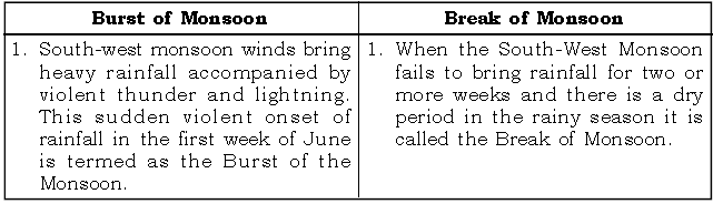
Question. Burst of Monsoon and Break of Monsoon.
Answer:
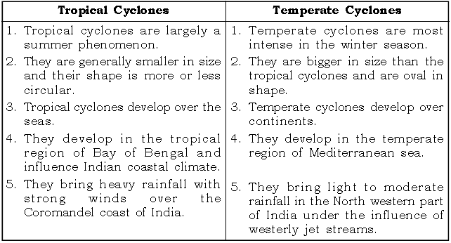
Question. Tropical Cyclones and Temperate Cyclones.
Answer:
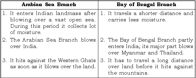
Question. Arabian Sea Branch and Bay of Bengal Branch of south west monsoon winds.
Answer:
Study the climatic data given below and answer the questions that follow:
Question.

(i) What is the annual range of temperature at the station?
Answer. Annual Range of Temperature
= Highest temperature – the lowest temperature
= 33.1ºC – 23.1ºC = 10ºC
(ii) Name the season during which the rainfall is heaviest.
Answer. The rainfall is generally received during the Winter season / Cold Season
/ Season of Retreating Monsoon / North East Monsoon Season.
(iii) What is the mean annual temperature of the station ?
Answer. Mean Annual temperature

Question.

(i) What is the annual range of temperature at station A?
Ans. Annual of Temperature = highest temperature – lowest temperature range
= 31.5ºC – 14ºC
= 17.5ºC
(ii) Which of the two places has greater influence of the sea? Give a reason for your answer.
Ans. The place that has lower annual range of temperature has greater influence of the sea.
In the example given above – The Annual Range of Temperature of station A
= 31.5°C – 14°C
= 17.5°C
The Annual Range of Temperature of station B = 29ºC – 7ºC
= 22°C
Therefore station A has greater influence of the sea.
(iii) Which of these stations have more equable climate?
(Note : This question is same as Q.(ii) but worded differently.)
Ans. The station which has lower annual range has more equable temperature.
In this case it is station A.
(iv) What is the annual rainfall received at station A?
Ans. Annual rainfall = Sum total of rainfall received in all the months.
The annual rainfall received at station A
= 0.5 + 5 + 30 + 48 + 75 + 38 + 10 + 2
= 208.5 cms.
(v) Which winds bring rainfall to station A and station B respectively?
Ans. Station A receives more rainfall from June to September / October, hence it is the South-West monsoon winds. Station B receives more rainfall is
more from November to February, hence it is North East Monsoon winds.
(vi) What is the mean annual temperature of station B?
Ans. Mean Annual temperature


