Students of ICSE Class 10 should refer to Climate ICSE Class 10 Geography previous year questions and solutions. below which have come in past board exams. You should always go through questions that have come in previous years. This will help you to understand the pattern of questions in ICSE Class 10 Geography and prepare accordingly. This will help you to get better marks in ICSE Class 10 Board Exams
Short Answer Type Questions
Question: (i) Why is the annual range of temperature more at Agra than at Mumbai?
(ii) Name a region in India which receives rainfall both in summer and winter.
Answer: (i) Since Agra is situated in the interior part of the country and is experiencing the Continental type of climate
and Mumbai is a coastal city experiencing equable climate therefore annual range of temperature at Agra is more.
(ii) North West part of India like Punjab, Delhi, Uttarakhand.
Question: Give two reasons why Arabian Sea branch of the South West Monsoon does not shed any moisture
in Western Rajasthan.
Answer: (i) The Aravalli Hills lie parallel to the South West Monsoon winds coming from the Arabian Sea and thus cannot shed any moisture in Western Rajasthan.
(ii) The temperature of the region is so high in summers that the monsoon winds get dry and do not shed any rain there.
Question: What is the name given to climate of India? Mention any two factors responsible for such a
type of climate.
Answer: Tropical monsoon climate.
(ii) Effect of monsoon wind / Latitudinal extent / Tropic of cancer passing through its centre / effect of Himalayas.
Question: Name the following:
(i) The winds that bring heavy rain to Cherrapunji.
(ii) The local wind that bring a light rainfall to South India and is good for tea and coffee crops.
Answer: South West monsoon winds from the Bay of Bengal branch.
(ii) Mango Showers or Cherry Blossoms.
Question: State two differences between the rainfalls, that occur from June to September and that from
December to February in North India.
Answer: Rainfall in Rainfall in June – Sep Dec – Feb Orographic Cyclonic Heavy/torrential Light Causes destruction Beneficial
Question: State the benefits that are derived from the local winds that blow in summer in the following states:
(i) Kerala
(ii) West Bengal
Answer: (i) Kerala- Mango showers are good for the tea and coffee crop.
(ii) West Bengal- Nor’ wester is good for the rice and jute crop.
Question: Mention the different sources of rain in Punjab and Tamil Nadu during the winter season.
Answer: Punjab -rain from the westerly depressions/western disturbances. Tamil Nadu – rain from the north east
monsoons.
Question: Rainfall in India is Orographic in nature.’ Give an example with reference to the distribution of
rainfall and the effect of relief on its distribution.
Answer: Mountains or relief is responsible for the distribution of rainfall in India. For example, the Western Ghats
act as a barrier for the south west monsoon winds which results in heavy rainfall on the windward side of the Ghats while the leeward side of the Western Ghats remains dry.
Question: Mumbai receives rainfall in the summer season while Chennai receives rainfall from October to
December. Why?
Answer: Mumbai lies on the windward side of the Western Ghats and receives rainfall from the south-west
monsoon in the summer season while Chennai is located on the eastern side and receives rainfall from
the retreating north-east monsoon winds which picks up moisture from the Bay of Bengal and shed rainfall there.
Question: Name the source of winter rain in Tamil Nadu. How does Tamil Nadu benefit from it?
Answer: The retreating North-East winds which picks up moisture from the Bay of Bengal and shed rainfall in Tamil Nadu. This rain is beneficial for growing rice and coffee.
Question: Which type of climate is experienced in the Northern Plains of India? State one main
characteristic of this type of climate.
Answer: The Northern Plains of India experiences continental type of climate. Its main characteristic is that it is too hot in summers and too cold in winters and has a high range of temperature.
Question: Mangalore and Mysore lie approximately on the same latitude yet Mangalore receives its annual rainfall from June to September while Mysore gets its rain in November and December. Explain.
Answer: Mangalore lies on the windward side of the Western Ghats on the west coast of India while Mysore lies
on the leeward side of the Eastern Ghats. During summer, the south west monsoon winds strikes the Western Ghats and shed good amount of rainfall whereas the east coast receives rain from the northeast monsoon winds that picks up moisture from the Bay of Bengal.
Question: Name the area in India which receives rainfall from the western disturbances. State the importance of
rainfall caused by Western Disturbances.
Answer: The North West part of India, i.e. Punjab, Haryana, Delhi, Uttarakhand, western Uttar Pradesh etc.
receives rain from Western Disturbances. This rainfall is beneficial for the cultivation of Rabi crops i.e. wheat and barley.
Long Answer Type Questions
Question: Study the climatic data of two cities of India provided below and answer the questions that follow:

(i) Calculate the annual range of temperature of Station A.
(ii) What is the total rainfall experienced by Station B?
(iii) On which coast is Station A situated? Name the winds that bring rainfall to this region.
Answer: (i) Station A Annual Range of temperature= Maximum temperature – Minimum temperature
32.5 – 24.5= 8°C
(ii) 183.2 cms.
(iii) Station A is situated on the eastern coast. Retreating North-East winds bring rainfall to this region.
Question: Give a geographical reason for each of the following:
(i) Kanpur has extreme temperature conditions.
(ii) Kochi is warmer than Mumbai even though both lie on the western coast of India.
(iii) The Ganga Plain gets the monsoon rain much later than the west coast of India.
Answer: (i) Kanpur lies in the interior, far from moderating effect of the sea.
(ii) Kochi is warmer because it is closer to the Equator than Mumbai.
(iii) It is because the Monsoon winds come to India from the south west and so reach the west coast before it can reach the Ganga plain.
Question: Study the climatic data of station X given below and answer the questions that follow:

(i) Calculate the total annual rainfall experienced by the station.
(ii) What is the annual range of temperature?
(iii) On which coast of India does the station lie? Give a reason for your answer.
Answer: (i) Annual rainfall- 128.7 cm.
(ii) 32.5° C – 24.5° C = 8°C
(iii) East Coast. It gets most of the rain in the season of retreating monsoon.
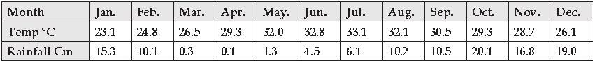
Question: Study the climatic data of station X given below and answer the questions that follow:

(i) Identify the hottest month.
(ii) Calculate the annual rainfall.
(iii) Name the winds that bring the maximum rainfall to this city.
Answer: (i) Hottest month- May.
(ii) Annual rainfall- 131.9 cm.
(iii) Retreating Monsoon.
Question: Study the climatic data of station X given below and answer the questions that follow:

(i) Calculate the annual temperature range.
(ii) What is the total annual rainfall?
(iii) Presuming that the station is located in India, give a reason for its location being on the east
coast or the west coast of India.
Answer: (i) 36.2° C – 24.6° C= 11.6° C
(ii) Annual Rainfall- 140.9 cms.
(iii) The station is located on the east coast because it gets most of its rain in the winter months.
Question: Study the climatic data of station X given below and answer the questions that follow:
(i) Calculate the annual rainfall experienced by the station.
(ii) Suggest a name of this station, giving a reason for your answer.
(iii) Name the season during which the rainfall is heaviest.
Answer: (i) Annual Rainfall- 114.3 cms.
(ii) Chennai, because it is receiving most of its rainfall from October to December.
(iii) Retreating Monsoon Season.
Question: Study the climatic data of station X given below and answer the questions that follow:

(i) Calculate the mean annual temperature.
(ii) What is the total rainfall during the monsoon season?
(iii) Does the station have a maritime or a continental climate? Give a reason for your answer.
Answer: (i) Mean Annual temperature- 28°C
(ii) Total rainfall- 180.5 cms.
(iii) The station has a maritime climate as the range of temperature is very low i.e. 6.6°C.
Question: Give a reason to explain why: [ICSE, 2011]
(i) The coastal areas of India do not experience a significant variation in temperature between
summer and winter months.
(ii) The annual rainfall in Rajasthan is less than 25 cm.
(iii) The Coromandel Coast gets most of its rain during the winter season.
Answer: (i) It is due to the effect of land and sea breeze caused by the differential rate of heating and
cooling of the land and sea which results in an equable and moderate climatic conditions.
(ii) The Aravalli hills lie parallel to the south west monsoon winds of the Arabian Sea branch
and do not hinder the winds. Thus, Rajasthan remains dry. On the other hand, the winds blowing from the Bay of Bengal branch sheds its moisture on its way and gets dry by the time it reaches Rajasthan. Rajasthan also lies on
the leeward side of the Aravalli Hills and thus receives less than 25 cm of rainfall.
(iii) The Coromandel Coast, situated on the eastern coast, receives rain in winter due to the cyclonic depressions
that prevail over the Bay of Bengal due to low pressure conditions. It doesn’t receive rain in summer as it lies in the
leeward side of the Arabian Sea branch.
Question: Study the climatic data of station X given below and answer the questions that follow:

(i) Name the driest month.
(ii) Calculate the annual rainfall experienced by the station.
(iii) What is the annual range of temperature?
Answer: (i) The driest month is March with the least rainfall of 1.3 cms.
(ii) The annual rainfall is 129.2 cms.
(iii) The annual range of temperature is 32.5 – 20.4 = 12.1°C
Question: Give reasons for the following:
(i) The North East monsoons bring almost no rain to most of India.
(ii) The Mango Showers are beneficial local winds.
(iii) The latitudinal extent of India is responsible
for the variation in the climatic conditions which prevail in the country.
Answer: (i) The North East monsoon winds blow over most part of India from land to the sea and thus, don’t bring any rain to most of India.
(ii) The Mango Showers are beneficial for the growth of mango, tea and coffee.
(iii) The latitudinal extent of India is between 8° N to 37° N and the Tropic of Cancer passes through the centre of India. The southern part of India lies in the tropical zone and experiences high temperature throughout the year while the northern part lies in the temperate zone and experiences extremity of temperatures i.e. too cold in winters and too hot in summers.
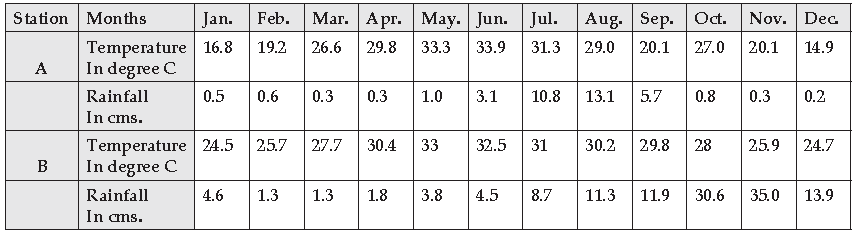
Question: Study the climatic data provided below and answer the questions that follow:

(i) Calculate the annual range of temperature of Station B.
(ii) Calculate annual rainfall of Station A.
(iii) Presuming that both the stations are located in West India, state giving a reason as to which
of the two lies on the windward side of the Western Ghats.
Answer: (i) Annual Range of temperature of Station B is 30.0°C – 24.4°C= 5.6°C.
(ii) Annual rainfall of Station A is 67.4 cms.
(iii) Station B since it receives heavy amount of rainfall in the month of June- July, i.e. 50.2 cms
and 61.0 cms respectively
Question. Study the climatic data of station X given below and answer the questions that follow:

(i) Calculate the annual range of temperature of Station A. Suggest a reason why the range is a small one.
(ii) Which of the two Stations has the lower temperature? Why?
(iii) Calculate the annual rainfall of Station B.
Answer: (i) Annual range of temperature of Station A is 30.0°C – 24.4°C = 5.6°C. The range is a small
one because it is a coastal city.
(ii) Station B has the lower temperature because it is situated at a high altitude of about 800 m
above the sea level.
(iii) Annual rainfall of Station B is 31.8 cms
Question: Given below is the climatic data of a station. Study the table and answer the questions that follow:

(i) Calculate the annual range of temperature.
(ii) What is the total rainfall experienced by the station?
(iii) Which is the driest month?
Answer: (i) Annual range of temperature is 33.5°C – 13.7°C = 19.8°C
(ii) Total rainfall is 67.4 cms.
(iii) November is the driest month.
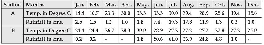
Question: Study the table given below and answer the questions that follow:

(i) Calculate the annual rainfall in Station A.
(ii) What is the annual range of temperature in Station B?
(iii) Which of the two stations has an equable climate?
Answer: (i) Annual rainfall of Station is 67.0 cms.
(ii) Annual range of temperature in Station B is 33.0°C – 24.4°C = 5.6°C
(iii) Station B has an equable climate.
Question: Study the table given below and answer the questions that follow:

(i) Calculate the annual rainfall in Station A.
(ii) What is the annual range of temperature in Station B?
(iii) Name the winds that bring most of the rainfall to Station B. State one reason for your answer.
Answer: (i) Annual rainfall of Station A is 68.4 cms.
(ii) Annual Range of Temperature of Station B is 33.1°C -23.1°C = 10°C
(iii) The North East monsoon winds bring most of the rainfall to Station B. From the month of October to December, the winds while crossing the Bay of Bengal picks up moisture from there, enters the eastern coasts and strikes the Eastern Ghats and sheds rainfall.
Question: Study the table given below and answer the questions that follow:
(i) Calculate the Average Annual Rainfall for Station B.
(ii) Which of the two stations is located away from the sea? Give a reason to justify your answer.
(iii) Calculate the Annual Range of Temperature for Station A.
(iv) Which is the driest month in Station A as shown in the table?
Answer: (i) Average Annual Rainfall of Station B is 128.7 ÷ 12 = 10.72 cms. (Total Annual Rainfall ÷Total no.of months)
(ii) Station A is located away from the sea because the range of temperature is high.
(iii) Annual Range of Temperature for Station A is 33.9°C – 14.9°C = 19°C.
(iv) December is the driest month in Station A.
Question: Study the climatic data given below and answer the questions that follow:
(i) Calculate the annual rainfall for Station A.
(ii) What is the annual range of temperature at Station B?
(iii) In which hemisphere do you think Station A lies?
(iv) Which of these stations has an equable climate?
Answer: (i) Annual Rainfall for Station A is 67 cms.
(ii) Annual Range of temperature at Station B is 30.0°C – 24.4°C = 5.6°C
(iii) Station A lies in the Northern Hemisphere.
(iv) Station B has an equable climate
Factors Affecting Climate and Seasons
Short Answer Type Questions
Q.1. Name the factors that influence the climate of India or South Asia.
Answer: The factors that influence the climate of India are-
(a) Latitude- the further one moves away from the equator, the colder it gets as the rays of the sun get more oblique. Hence places in the south like Kochi, Chennai, Bangalore and others are warmer than places in the north like Delhi, Agra, Srinagar and others due to proximity to the equator.
(b) Altitude- the higher one goes above sea-level, the colder it gets as the atmosphere is heated from below. Hence places at a higher altitude like Simla, Mussourie, Panchgani and others are cooler than places at sea level like Mumbai, Bhopal, Jaipur and others.
(c) Distance from the sea- the further one moves away from the sea, the higher will be the range of temperature. Hence places like Mumbai, Chennai,Kolkata and others will have an equable climate as they experience the moderating influence of the sea, while places further inland like Pune, Indore, Hyderabad, Amritsar, Delhi and others will have a continental type /extreme type of climate. [Any relevant examples]
(d) Varied Relief- When mountains lie perpendicular to onshore winds, heavy rainfall occurs on the windward side and scanty rainfall occurs on the leeward side; and when mountains lie parallel to rain-bearing winds, little rain falls. E.g Aravallis – Thar / Rajasthan./ So places that lie on the windward side of mountains like Mumbai, Cherrapunji and others will receive more rain than places that lie on the leeward side of mountains like Pune, Shillong and others. Alignment of mountain ranges/ Presence of Himalayas- Checking the South West Monsoons from blowing into
Question: What is the direction of the summer monsoon? Why?
Answer: The direction is South West. The intense heat during summers in India develops low pressure over the Northern Plains and high pressure over the sea. This low pressure attracts the moisture bearing winds from the southern hemisphere. After crossing the equator, they are deflected to the right and blow over India as the south west monsoon winds.
Question: Give two reasons as to why the entire Indian Sub- Continent has the tropical monsoon climate.
Answer: (i) India lies in the tropical belt.
(ii) The climate is influenced by the monsoon winds which are largely confined to the Tropics, i.e. between
20°N and 20°S.
Question: Mention two main features of the Indian monsoon.
Answer: Two main features of the Indian monsoon-
(i) Monsoon is erratic and sporadic.
(ii) Monsoon is unevenly distributed.
Question: State two differences between tropical cyclones and temperate cyclones.
Answer:

Question: What are Western disturbances? How do they affect the climate of India?
Answer: The cyclonic winds originating over the Mediterranean Sea are called Western Disturbances. These winds blow towards India in the month of November and December and bring heavy rainfall over the North West part of India.
Question: Why is there great variations in the climate of the Indian Sub-Continent?
Answer: Due to location, vast extent of the country, presence of the lofty Himalayan Mountain, large coastline
along the eastern and western sides and the Western Disturbances, there is a great variation in the climate of the Indian Sub-Continent.
Question: (i) Name any two states that receive rain in January-February.
(ii) What causes this rain?
Answer: (i) Punjab and Uttrakhand.
(ii) The Western disturbances or cyclonic depressions originating over the Mediterranean Sea.
Question: (i) Which winds are responsible for the rainfall experienced over the greater part of the Indian
Sub-Continent?
(ii) During which months of the year is this rainfall experienced?
Answer: (i) South West Monsoon winds are responsible for the rainfall experienced over the greater part of
the Indian Sub-Continent.
(ii) From June to September.
Question: “Shillong gets less than 200 cms of rainfall in the year while Cherrapunji receives more than 1250
cms of rainfall”. Give two reasons.
Answer: (i) Shillong lies on the rain shadow area or the leeward side of the Khasi Hills while
Cherrapunji lies on the windward side.
(ii) The moisture laden winds coming from the Bay of Bengal branch gets entrapped in the
Garo-Khasi Hills and causes heavy rainfall.
Quesyion: (i) Name the season during which the North East Trade Wind dominate the Indian Sub- Continent.
(ii) In which season do the above mentioned winds get completely reversed? Name the
four months covered by this season.
Answer: (i) During the Cold weather or winter season the North East Trade Winds dominates the Indian Sub-Continent.
(ii) The North East Trade Winds get completely reversed in the Summer Season.
The four months covered by this season are October, November, December and January.
Long Answer Type Questions
Question: Give a geographic reason for each of the following:
(i) Kerala has the longest rainy season.
(ii) The Konkan coasts experiences orographic rainfall.
(iii) The city of Kanpur in Uttar Pradesh has a higher range of temperature than that of Chennai in Tamil Nadu.
Answer: (i) Kerala lies to the SW and hence it is the first state to receive rain from SW Monsoon of the Arabian Sea branch as these winds move from SW to NE. These winds withdraw from North and move towards south and hence Kerala is the last state from which these winds withdraw. Thus, Kerala is the first state to receive the South-West Monsoon and the last to see it withdraw.
(ii) The Konkan coast lies on the windward side of the Western Ghats and hence receives heavy rain from the SW Monsoon winds from the Arabian Sea branch. The windward side of an area is the slope of a range that receives heavy rainfall.
(iii) Kanpur lies to the interior, far away from the influence of the sea, whereas Chennai lies along the coast and is influenced by the sea. Thus, Kanpur is deprived of the moderating influence of land and sea breeze.
Question: Mention a geographical reason for each of the following:
(i) Patna receives heavier rain than Delhi.
(ii) Western Rajasthan receives no rain from the Arabian Sea branch of the South West Monsoon winds.
(iii) Mangalore is not cold even in the month of December.
Answer: (i) Patna gets a much heavier rain than Delhi does because Patna lies in the lower Ganga valley
while Delhi lies in the upper Ganga valley and the Bay of Bengal branch of the South West of Bengal branch
deflects when it comes in contact with the Garo Khasi and Jaintia Hillsin Assam moving up the Ganga Valley.
The rain shed while following the line of the.
(ii) Western Rajasthan gets no rain from the Arabian Sea Branch of the South West Monsoon winds because it
blows parallel to the Aravali mountains and therefore shed no moisture.
(iii) It never gets too cold in Mangalore, not even in December because of the moderating influence
of the land and sea breezes and because it is quite close to the equator
Question: Give reasons for the following:
(i) When the Malabar Coast is receiving heavy ainfall in July, the Tamil Nadu coast is comparatively dry.
(ii) The Northern Plains of India have a Continental type of climate.
(iii) Central Maharashtra receives little rainfall.
Answer: (i) It is so because Tamil Nadu lies in the rain shadow region of Arabian Sea branch and the
Bay of Bengal is parallel to the coast.
(ii) It is so because the northern Plains are located far away from the influence of the sea.
(iii) Central Maharashtra receives little rainfall because it lies in the rain shadow region of the Western Ghats.
Question: Give geographical reasons for the following:
(i) Even in summer Shimla is cooler than Delhi.
(ii) The northern plains of India do not freeze in winter.
(iii) Kochi has a lesser annual range of temperature than Agra.
Answer: (i) Shimla is situated at a higher altitude than Delhi. Thus, due to lapse rate, as one moves up
the altitude, the temperature decreases.
(ii) The cold winds from the north are prevented from entering into India due to the presence
of the lofty Himalayas and thus helps to keep the temperature of the northern plains at a moderate level.
(iii) Kochi is a coastal city and is influenced by the sea while Agra is situated in the interior part of the country experiencing continental type of climate. Thus, Kochi has a lesser annual range of temperature than Agra.
Question: Give a reason for each of the following:
(i) Patna gets a heavier rainfall than Varanasi.
(ii) The Arabian Sea branch of the South West Monsoon does not shed any moisture in Western Rajasthan.
(iii) India has varied climatic conditions.
Answer: (i) The South West monsoon winds of the Bay of Bengal branch while advancing towards North West sheds heavy rainfall on Patna as it falls first on its way and then the amount of rainfall decreases by the time it reaches Varanasi.
(ii) The Aravalli Hills lie parallel to the South West Monsoon winds coming from the Arabian Sea and thus cannot shed any moisture in Western Rajasthan.
(iii) India has varied climatic conditions because of large latitudinal and longitudinal extent, altitude and distance from sea.
Question: Give reasons for the following:
(i) It is cooler on the mountain slopes than in the plains during summer.
(ii) Mumbai is warmer than Kanpur in December.
(iii) Rajasthan receives very little rainfall.
Answer: (i) The mountain slopes are cooler than the plains during summer due to normal lapse rate i.e. with every 165 meters of ascent there is a fall of 1°C of temperature.
(ii) Mumbai is warmer than Kanpur in December because Mumbai is a coastal city and has the influence of sea which results in moderate climate.
(iii) Rajasthan receives very little rainfall because Aravalli Hills lie parallel to the South West Monsoon winds coming from the Arabian Sea branch.
Question. Name the place in India which receives the heaviest rainfall.
Answer: Cherrapunji and Mawsynram
Question. Name the factors which affect the climate of a place.
Answer: Temperature, humidity, Precipitation, atmospheric pressure and winds..
Question. What is ‘Monsoon’?
Answer: The term ‘monsoon’ is derived from an Arabic word ‘Mausim’ meaning season.
Question. What are the two types of cyclonic systems that affect India? Name any two areas that receive rainfall from these cyclonic systems.
Answer: The two cyclonic systems that affect India are :
(i) Tropical cyclones, which affect Coromandel Coast i.e. the coast of Tamil Nadu Coast, Orissa and Andhra Pradesh.
(ii) Temperate Cyclones, which affect Punjab, Haryana, Himachal Pradesh and Uttar Pradesh.
Question. Why do tropical cyclones originate over Bay of Bengal ?
Answer: (i) Tropical Cyclones are low-pressure systems called ‘tropical depressions.’
(ii) They originate over the Bay of Bengal due to local variation in heat and moisture in the atmosphere.
(iii) They generally originate in the region around Andaman Islands between latitudes 12ºN and 17ºN and move in west or north-west direction over the Bay of Bengal and bring rain to eastem coastal region of India.
Question. Mention the different sources of rain in Punjab and Tamil Nadu during the winter season.
Answer: (i) Punjab gets winter rainfall due to western disturbances.
(ii) Tamil Nadu receives rainfall during winter rains from North East winter Monsoon.
Question. Despite the broad climatic unity, the climate of India has many regional variations. Justify this statement giving suitable examples.
Answer: Despite the broad unity of the monsoon type of climate, variations in climate occur in different regions of the country.
Examples of these variations are:
(i) Barmer in Rajasthan may record a temperature of 48°C or 50°C on a June day, while it hardly reaches 22°C at Pahalgam or Gulmarg in Kashmi r on the same day . Howe ve r, in Dras n e ar Kargi l , the temperatures may go down to -40°C during winter.
(ii) Kerala has tropical climate with warm and moist air, whereas Punjab has continental climate with severe heat alternating with severe cold.
Question. Why Chennai has a lower annual range of temperature than Lucknow?
Answer: (i) Chennai lies in coastal area hence experiences moderating influence of land breezes and sea breezes and therefore has lower annual range
of temperature whereas Lucknow has continental type of climate and does not have influence of land breezes and sea breezes.
(ii) Hence Lucknow has very high temperature in summer and low t emp e r a t u r e i n wi n t e r wh i c h g i v e s h i g h e r a n n u a l r an g e o f
temperature.
Question. What is El-Nino’ effect?
Answer: (i) El-Nino is a warm ocean current that sometimes appears off the coast of Peru in the South Pacific ocean, during December.
(ii) It increases surface temperature of the ocean and can affect the movement of ocean winds in the Indian ocean, causing drought in the Indian subcontinent.
Question. Name the seasons during which the North-East Trade Winds dominate. How does these winds affect the climate of India ?
Answer: (i) The North East trade winds prevail over India during the cold and dry winter season.
(ii) These winds blow from land to sea and hence, for most part of the country it is a dry season.
(iii) However when these winds blow over Bay of Bengal they absorb moisture and cause some amont of rainfall on the Coromandel coast.
Question. What are ‘Western Disturbances’? What is their influence on the climate of India ?
Answer: (i) Western Disturbances are also known as Westerly Depressions. These are Temperate Cyclones that originate in the Mediterranean sea and
blow eastwards.
(ii) In India, they blow over the northern plains, mainly over Punjab and Haryana during winter.
(iii) They bring little rainfall over the region. This rain is very good for better yield of wheat (rabi) in the region.
Question. Kochi has a lesser annual range of temperature than Agra.
Answer: (i) Agra has continental type of climate as it lies in the in interiors away from the sea therefore has very high temperature in summer and low
temperature in winter.
(ii) Whereas Kochi lies in coastal area. Hence it has moderating influence of land breezes and sea breezes leading to less difference between summer and winter temperature.
Question. The Coromandel coast gets most of its rain during the winter season.
Answer: (i) The Coromandel coast lies to the east of the Eastern Ghats.
(ii) These mountains block the north-east monsoon winds that pick up moisture from the Bay of Bengal.
(iii) Thus due to the obstruction provided to these winds by the Eastern Ghats, the Coromodel coast gets rainfall in winter.
Question. Name two regions which get very little rain from the Summer Monsoon.
Answer: Rajasthan and Jammu and Kashmir.
Question. Name any two states that receive rain in January-February.
Answer: Tamil Nadu, Punjab.
Question. Kanpur has extreme temperature conditions.
Answer: Kanpur is situated in the interior parts of the country and is away from the moderating influence of the sea. So it is very cold in winter and very hot in summer.
Question. Kochi is warmer than Mumbai even though both lie on the western coast of India.
Answer: Kochi is located closer to the equator whereas Mumbai is not. So as Kochi experiences vertical rays of the sun, it is warmer than Mumbai.
Question. The Ganga Plains gets the monsoon rain much later than the west coast of India.
Answer: Ganga plain lies in North India and the Southwest monsoon, first strikes the west coast of India, before North India.
Question. Punjab gets rain in winter.
Answer: Punjab gets rain in winter because Punjab comes under the influence of Western disturbances which move eastwards from the Mediterranean region
and bring rainfall to the northwest India during winter season.
Question. The Indo-Gangetic Plain gets some rainfall in the months of December and January.
Answer: During the winter season the Indo-Gangetic Plain comes under the influence of Western disturbances and hence it gets some rainfall in the months of December and January.
Question. When the Malabar coast is receiving heavy rainfall in July, the Tamil Nadu coast is comparatively dry.
Answer: (i) Malabar coast gets rainfall from Arabian Sea Branch of the South West Monsoon winds.
(ii) Whereas in case of Tamil Nadu coast it is parallel to Bay of Bengal Branch of South West Monsoon winds and lies in the rain shadow area of Arabian sea branch of the South West Monsoon winds. Thus it remains comparatively dry.
Question. Most parts of India do not receive rainfall in winter season.
Answer: During winter season north east trade winds prevail over the country. As there winds blow from land to sea, most parts of India experiences dry season (no rainfall) except the Coromandel coast.
Question. Tamil Nadu Coast remains dry during “South West Monsoon Season”.
Answer: Tamil Nadu remains dry during ‘south west monsoon season’ as it lies in the rainshadow region of the Western Ghats and parallel to the Bay of
Bengal branch of south west monsoon winds.
Question. Both Mangalore and Bangalore are almost on same latitude. Yet Mangalore receives much more rainfall than Bangalore.
Answer: (i) Mangalore lies on the West coastal plains (to the west of Western Ghats).
(ii) The Western Ghats block the Arabian Sea branch of South West Monsoon winds and cause heavy orographic rainfall over Mangalore. Bangalore lies in the rain-shadow region of Western Ghats. Therefore it receives very less rainfall.
Question. Mumbai receives vertical sunrays twice a year while Delhi does not receive the same even once.
Answer: (i) Mumbai lies to the south of Tropic of Cancer while Delhi lies to the north of Tropic of Cancer.
(ii) Since the apparent vertical movement of the sunrays is limited only between Tropic of Cancer and Tropic of Capricorn, Mumbai receives vertical sunrays twice a year while Delhi does not receive them even once.
Question. What is meant by ‘Burst of Monsoon’?
Answer: South-west monsoon winds bring heavy rainfall accompanied by violent thunder and lightning. This sudden violent onset of rainfall in the first week of June is termed as the ‘Burst of the Monsoon’.
Question. Name any two local winds which blow in India during the summer season.
Answer: (i) Strong dusty winds called ‘loo’ blow over northern and northwestern India during day time.
(ii) Strong winds blow over Assam known as ‘Bardoli Chheerha’.
Question. What is meant by ‘rain shadow area’? Give an example and state the mountains which are responsible for the rain shadow area.
Answer: (i) The leeward side of the mountain which receives very low rainfall is called the ‘rain shadow area’.
(ii) For e.g. the eastern slopes of Western Ghats is a rain shadow area for the southwest monsoon winds.
Question. Name an area which gets sufficient rainfall from the winter monsoon.
Answer: Tamil Nadu gets sufficient rainfall from the winter monsoon.
Question. State the features of North – East Monsoon season ?
Answer: The special characteristics of this season are as follows :
(i) Temperature in general decreases from south to north. Kashmir and other adjoining hilly regions experience snowfall.
(ii) Clear skies, cool weather, light northerly winds and low humidity is experienced.
(iii) Punjab, Haryana, Jammu and Kashmir, Himachal Pradesh, Northern Raj asthan and Uttarkhand re ceive li ght rainfall from We sterly depressions from the Mediterranean sea. They move parallel to the Himalayas in the northern plains and cause some rainfall over the northern belt up to Assam and Arunachal Pradesh in the north-east.
(iv) As the land is colder than the water-bodies, there is high pressure over the landmass and low pressure over the water bodies. The region to the south of Tropic of Cancer has a temperature above 20ºC due to more vertical sunrays and the moderating influence of the sea.
Question. Name one region which gets rainfall from the Retreating Monsoon.
Answer: Chennai gets rainfall from the Retreating Monsoon.
Question. Kolkata receives heavier rain than Lucknow.
Answer: (i) The Bay of Bengal branch of South-West monsoon is deflected towards the west along the Himalayas.
(ii) The rainfall goes on decreasing as it proceeds through the Ganga valley on its way it gives more rainfall to Kolkata in West Bengal.
(iii) By the time it reaches Lucknow in Uttar Pradesh, it sheds less moisture.
Question. How relief plays an important role in climatic conditions of India ?
Answer: (i) Relief plays an important role in the climatic conditions of India. The Western Ghats get heavy rainfall on western side because they stand in
the way of south west monsoon winds which come from the Arabian Sea.
(ii) On the other hand, the Deccan Plateau gets less rainfall as it is lies in the rain shadow area of the Western Ghats.
(iii) In Rajasthan, the Aravalli Range is parallel to the direction south west monsoon winds. So it is unable to stop the moisture laden winds. This makes Rajasthan a dry area.
(iv) The southern hills of Assam get heavy rainfall but the northern ones do not. This is because the southern hills force the moisture laden winds to shed their moisture before they proceed northwards.
Question. State any four characteristics of South West Monsoon ?
Answer: (i) These winds blow from June to September.
(ii) The direction of these winds is from South West to North East.
(iii) They bring heavy rainfall. This is a high temperature and high humidity season. The pressure is low on the land area and high over surrounding water bodies.
(iv) During these months South West Monsoons cover the whole of India.
Question. What are some of the special characteristics of the Bay of Bengal Branch of South West Monsoons?
Answer: (i) It brings much rainfall to Andaman Nicobar islands, Bangladesh, Myanmar and eastern states of India.
(ii) It blows parallel to the Coromandel coast towards the eastern part of India.
(iii) These winds are blocked by the Garo Khasi and Jaintia hills, causing highest amount of annual rainfall in the world at Cherrapunji and at Mawsynram on the windward slope of Khasi hills (about 1200 cms).
(iv) After reaching the Eastern Himalayas, they deflect towards the west, parallel to the Himalayan range and thus cause rainfall in the Gangetic valley in West Bengal, Bihar, Uttar Pradesh and Uttarakhand.
(v) They also bring rainfall to the eastern slopes of Aravalli range. As the Aravalli acts as a barrier, they do not cause any rainfall over Thar desert region.
Question. In spite of Aravalli Range Rajasthan receives very less rain.
Answer: (i) In Rajasthan, the Aravalli Range is parallel to the direction of the south west monsoon winds.
(ii) So it is unable to stop the moisture laden winds and thus receives very low rainfall.
Question. Patna receives heavier rain than Delhi.
Answer: (i) Patna receives heavier rain than Delhi because the Bay of Bengal branch of South-West Monsoon goes up the Ganga plain.
(ii) As it proceeds up the Ganga valley, the amount of rainfall keeps decreasing east to west.
(iii) Since Patna is located to the east of Delhi, it receives 102 cm of rainfall while Delhi gets 50 cm of rainfall annually.
Question. Western Rajasthan receives no rain from the Arabian Sea branch of the South West Monsoon winds.
Answer: (i) In Rajasthan, the Aravalli Range is parallel to the direction of the south west monsoon winds. So it is unable to stop the moisture laden winds.
(ii) Since the moisture laden winds are not obctructed by the mountains, they do not cause any precipitation in Western Rajasthan.
Question. State two important characteristic features of the Monsoon rainfall / Summer monsoon rainfall in India.
Answer: Main features of the monsoon rainfall in India are :
(i) There is rainfall over three months and the rest of the year is mostly dry. Seventy per cent of annual rainfall occurs in the rainy season.
(ii) The rains are mainly of relief type. The windward slopes of the mountains get more rainfall than the leeward side.
Question. Describe the process of retreat of the summer monsoon.
Answer: (i) The south-west monsoon starts retreating from northern India in early October.
(ii) In this season monsoon trough of low pressure over the Ganga plains becomes weaker due to apparent southward movement of the sun.
(iii) The low pressure conditions are transferred to the centre of Bay of Bengal which is marked by cyclonic depressions which originate over Andaman Sea.
Question. Why is western part of Rajasthan a desert region?
Answer: (i) The southwest monsoon winds blow parallel to the Aravalli and are thus not obstructed by them and therefore the rainfall is low in Rajasthan.
(ii) Secondly, the Arvallis are low residual hills and thus do not obstruct the southwest monsoon winds and therefore the rainfall is low.
Question. How Himalayas act as a climatic divide ?
Answer: (i) The Himalayas form a climatic barrier separating the Indian subcontinent from the rest of Asia.
(ii) They not only prevent the cold Siberian winds from entering the Indian region and from India becoming a cold desert but they also force the
moisture laden South West Monson winds to shed rainfall in India or else India would be a dry region.
Question. Describe effect of EL – Nino on Indian monsoon ?
Answer: (i) EL – Nino is a warm ocean current which sometimes appears off the coast of Peru in South America during the month of December.
(ii) It increases the surface temperature of the sea and affects the movement of monsoon winds in the Indian Ocean and cause weak drought like situation in the Indian sub – continent.
Question. What is known as ‘Summer Monsoon’ ?
Answer: (i) In summer, the land gets heated more than the sea, Hence there develops a centre of low pressure on the land.
(ii) Over the adjoining sea, the air is comparatively cool and a high pressure develops there.
(iii) This causes the winds to blow from the sea to the land. It is the ‘Summer Monsoon.’