Students can refer to the following Sample Paper ICSE Class 10 Geography Set C with Answers provided below based on the latest syllabus and examination guidelines issued for ICSE Geography. All specimen papers have been prepared covering all chapters given in ICSE Geography book for Class 10. You should also refer to ICSE Class 10 Geography Solutions.
Sample Paper ICSE Class 10 Geography Set C with Answers
Class:TEN Full Marks:80+20
Subject:GEOGRAPHY
Attempt seven questions in all. Part –I is compulsory .Aattempt five questions from PART II. All sub-parts of each question are to be answered in correct order. The intended marks for questions or parts of questions are given in brackets. [ ]
PART-I (COMPULSORY)
Study the Survey of India map 45D/10,(eastings 03-13,northings 08-18) and answer the following questions or parts of questions are given in brackets ( ).
QUESTION 1:
a. Define the following terms: stony waste and contours. [2]
b. Calculate direction of:
i. Settlement warka from settlement Serua
ii. The main river flowing in the map extract. [2]
c. What is the reason for : [2]
i. The existence of broken grounds near the river banks?
ii. The presence of number of causeways between Revdar and Karaunti?
d. What do you think is the main occupation of the people living in the area in the map extract and why? [2]
e. Give the 4 figure grid reference of brick kiln and temple near the village Asav ? [2]
f. Name the most prominent settlement? Give reasons to justify your answer. [2]
g. What is inferences can u give for seasonal rainfall in the map extract? [2]
h. What is the drainage pattern in grid 0816 and 0708 respectively? [2]
i. What is the distance in kilometre and meters of the metalled road from grid 0413 to settlement Karaunti ? [2]
j. What is the area of the region enclosed between eastings 06-10 and northings 13-17 in the map extract?
QUESTION 2: ON THE MAP OF INDIA, MARK: [1×10=10]
a. Label the river Satluj.
b. Mark with bold line and name Satpura range
c. Mark and label the city Kolkata.
d. Mark with arrows and name the wind that brings rain to Tamil Nadu in winter.
e. Shade an area of alluvial soil in south India.
f. Mark the oldest oil field of India.
g. Mark and label the Standard meridian
h. Label and name the Gulf of Mannar.
i. Shade and label the Northern Circars.
j. Mark and name the Nilgiri.
PART II (attempt any five)
QUESTION 3:
a. Give a reason to explain why:
i.The coastal areas of India do not experience significant variation in temperature between summer and winter months.
ii.The annual rainfall in Rajasthan is 25 cm.
iii.Even in summer Shimla is cooler than Delhi.
b. Define the following terms:
i.October heat
ii.Burst of monsoon
c. Explain the role of westerly depression as a factor influencing the climate of India.
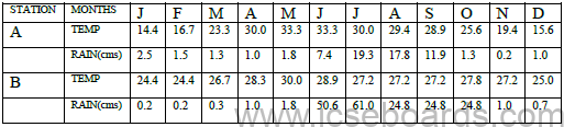
i. Calculate the range of temperature of station B.
ii. Give a suitable name of station A with logical reason.
iii. Which of the two stations has an equable climate?
QUESTION 4 :
a. Give reasons as to why:
i. Red soil is fit for dry farming.
ii. Laterite soil is found in areas of heavy rain.
b. Explain one conservation method of soil each in hilly area and in desert area.
c. Name the soil:
i.Is stricky when wet and cracks when dry.
ii.Makes up the delta of the river Ganga.
iii.Covers the summits of the Eastern Ghats.
iv.Found mostly in state of Meghalaya.
d. State the difference between alluvial soil found in the lower course and upper course of rivers.
e. Mention the two characteristics of laterite soil and two characteristics of black soil.
QUESTION 5:
a. With reference to Tidal forest, answer the following questions:
i.What are tidal forest?
ii.Name two trees found here.
iii.Name two characteristics of this natural vegetation.
b. Mention two reasons why tropical evergreen forests are difficult to exploit for commercial purpose?
c. What are the human activities responsible for depletion of forest?
d. How do forests:
i.Have a favorable effect on the climate of the region?
ii.Act as a flood control measure?
e. Name one important tree of the following:
i.Monsoon forest
ii. Desert forest
QUESTION 6:
a. i. Name two methods of water harvesting in India.
ii. Mention two objectives of rainwater harvesting.
b. Why is it necessary to develop modern methods of irrigation?
c. Which type of irrigation is best suited for Deccan trap region of India and why? Give two reasons in support of your answer.
d. Give one advantage and one disadvantage:
i. Canal irrigation
ii. Tube well irrigation
iii. Sprinkler irrigation
QUESTION 7:
a. With reference to Coal:
i.What is brown coal?
ii.Name one specific region in south India where it is found?
b. Name the following:
i.Largest coal field of India.
ii.Best variety of iron ore.
iii.An Offshore oil field.
c. State important uses of biogas in rural areas.
d. i. What is meant by inexhaustible source of energy?
ii.Give two examples of such inexhaustible source of energy.
iii.Why oil refineries is located near to the coastal area?
QUESTION 8:
a. How has poverty and fragmentation of land become problems of Agricultural India?
b. Mention two geographical conditions for the cultivation of:
i. Rice
ii. Cotton
c. Give reasons:
i.Tea bushes are pruned at regular intervals.
ii.Shifting cultivation is a destructive method of agriculture.
d. What are the three cropping seasons?
QUESTION 9:
a. Why is Mumbai called as the Cottonopolis of India? Give three reasons in favour of your answer.
b. Name two by products of sugar industry and one use of each of it.
c. Name one centre of the following:
i.Electronic goods.
ii.Tractors
d. Give reason for the following:
i.Mini Steel plan causes less pollution than integrated steel plant.
ii.Petrochemical products are call for the recent times.
QUESTION 10:
a. What are the 3 problems being faced by the Indian Railways?
b. What is Golden quadrilateral? Mention any two ways in which it will help in the economic development of the country?
c. Define the following terms:
i. Coastal shipping
ii. Inland waterways
e. Give reasons:
i. NE India is devoid of any railways.
ii. Peninsular rivers are not navigable.
QUESTION 11:
a. State two advantages of composting.
b. Mention two disadvantages of landfills.
c. Write a note on concept of 3Rs with suitable examples.
d. Define the following terms:
i. Dumping
ii. Biodegradable waste
iii. Vermicomposting