Students can refer to the following Sample Paper ICSE Class 10 Geography Set B with Answers provided below based on the latest syllabus and examination guidelines issued for ICSE Geography. All specimen papers have been prepared covering all chapters given in ICSE Geography book for Class 10. You should also refer to ICSE Class 10 Geography Solutions.
Sample Paper ICSE Class 10 Geography Set B with Answers
CLASS 10
GEOGRAPHY
Attempt seven questions in all. Part 1 compulsory. Any five from Part 2.
PART 1
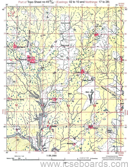
Question 1. Study the extract of the Survey of India Map Sheet No: 45 D/10 and answer the following questions: (20)
(a) (i) Give the four-figure grid reference of the settlement Jolpur.
(ii) Give the four-figure grid reference of Dhad Talao SE of settlement Dhann.
(b) (i) What is the compass direction of Idarla from Dantrai?
(ii) What does 2r in grid square 0626 means?
(c) (i) What is the drainage pattern in grid 0824?
(ii) What is the settlement pattern in grid 0725?
(d) (i) What is the value of contour line in grid square 0426?
(ii) What is the contour interval in the map?
(e) Mention any two factors which provide evidence that the region in the map extract is a rural region.
(f) (i) Name two natural features in 0318.
(ii) Name two man made feature in 0826?
(g) Calculate the area of the region between the Eastings 01 to 11 and Northings 25 to 28 in square kilometers.
(h) (i) What does 4r in grid square 0218 represents?
(ii) What does the tiny black curved lines in grid square 0721 represents?
(i) What is the occupation of the people residing in this region? Justify your answer.
(j) (i) What is the most commonly used means of transport in the area?
(ii) What does the black horizontal line near Northings 19 represents?
Question 2. (10) On the outline map of India provided mark and label.
(a) Label river Chambal.
(b) Shade and name Lake Chilka.
(c) Mark and label gulf of Munnar.
(d) Mark and label Indian Standard Meridian.
(e) Mark and label Delhi.
(f) Mark and label Mumbai High.
(g) Mark and label Satpura range.
(h) Shade and label a state in South India which has high population density.
(i) Mark and label Karakoram pass.
(j) Mark and label Northern Sircars.
PART 11
Question 3
(a) Mention two important features of Indian Monsoon. (2)
(b) Name: (2)
(i) The source of winter rain in Punjab.
(ii) The source of winter rain in Tamil Nadu.
(c) Name and explain the three local winds of India. (3)
(d) Given below is the climate data of a station. Study the table and answer the questions that follow
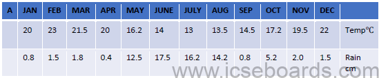
(i) Calculate the annual range of temperature of the station.
(ii) What is the total rainfall experienced by the station?
(iii) Name the driest and the wettest month.
Question 4.
(a) Name the soil which; (2)
(i) Makes up the delta of river Ganga.
(ii) Is the most suitable soil for cotton.
(b) Define reafforestation. How does it help in soil conservation? (2)
(c) What is leaching? Name the soil and the climatic conditions for its formation. (3)
(d) Give reasons: (3)
(i) Black soil is largely found in Deccan Trap region.
(ii) Khadar soil is more fertile than Bhangar.
(iii) Soil erosion is common in arid region.
Question 5.
(a) Why have the evergreen forests not been properly exploited? (2)
(b) Name two species of tree found in deciduous forests and its uses. (2)
(c) Name the agricultural practice which is destructive towards forest cover. Mention two policies adopted by Central Board of Forestry for the conservation of forests.(3)
(d) (i) Why are forests grown in and around the iron and steel industry? (3)
(ii)Why do trees of littoral forests have respiratory roots?
(iii)What is silviculture?
Question 6
(a) Mention two reasons to justify the need of artificial irrigation in India. (2)
(b) Mention two advantages of tube well over surface wells. (2)
(c) Give reasons: (3)
(i) Inundation canal is converted to perennial canals.
(ii) Sprinkler irrigation method is more popular in semi-arid regions.
(iii) Canal irrigation is more suitable in Northern Plains.
(d) Give three objectives of Rain Water Harvesting
Question 7.
(a)State the leading producers of the following minerals
(i) Iron. (ii) Oil (2)
(b)What is solar energy? State any one advantage of it.
(c) Mention two uses of manganese. Name two states leading in its production. (3)
(d)Name the types of coal. State two advantages petroleum have over coal as a fuel. (3)
Question 8
(a) Why are pulses so widely grown all over India? Give one reason why it is used as a rotation crop. (2)
(b) Which are the two staple crops of India? Name against each the season in which it is grown? (2)
(c) What are the climatic requirements to grow tea? Why is this crop grown in hill region? (3)
(d) Explain the terms: (3)
(i) Ginning.
(ii) Plucking.
(iii) Ratooning
Question 9.
(a) Why does India need industrialization? (2)
(b) Mention two problems faced by the cotton textile industry. (2)
(c) What are petrochemicals? Name any two products made from petrochemical (3)
(d) With reference to Rourkela Iron and Steel plant, answer the questions.
(i) From where does the plant gets iron ore?
(ii) Which river provides water?
(iii) Name the source of power supply.
Question 10.
(a) What is the significance of Border roads? (2)
(b) Give two ways in which rail transport is useful in India? (2)
(c) Give three reasons as to why airways are becoming popular means of transport? (3)
(d) (i) State one advantage of inland waterways.
(iii) State one advantage of roadways.
(iv) State one disadvantage of water transport.
Question 11
(a) Give two reasons as to why there is a need for safe waste disposal. (2)
(b) How can waste be reused? Explain with an example. (2)
(c) (i) What can an individual do to reduce waste at home? (3)
(ii)Why must segregation be done before disposal?
(iii)How has composting proven to be a great help in managing waste?
(d) Explain the terms: (3)
(i) E-waste
(ii) Dumping.
(iii) Incineration.