Students should refer to Interpretation of Topo Graphical Maps ICSE Class 10 Geography notes provided below designed based on the latest syllabus and examination pattern issued by ICSE. These revision notes are really useful and will help you to learn all the important and difficult topics. These notes will also be very useful if you use them to revise just before your Geography Exams. Refer to more ICSE Class 10 Geography Notes for better preparation.
ICSE Class 10 Geography Interpretation of Topo Graphical Maps Revision Notes
Students can refer to the quick revision notes prepared for Chapter Interpretation of Topo Graphical Maps in Class 10 ICSE. These notes will be really helpful for the students giving the Geography exam in ICSE Class 10. Our teachers have prepared these concept notes based on the latest ICSE syllabus and ICSE books issued for the current academic year. Please refer to Chapter wise notes for ICSE Class 10 Geography provided on our website.
Interpretation of Topo Graphical Maps ICSE Class 10 Geography
Part 1: Map Work
Chapter – 1 : Interpretation of Topo-Graphical Maps
Quick Review
➢ A topographic map is a detailed and accurate graphic representation of cultural and natural features that appear on the earth’s surface.
➢ Topographic maps have multiple uses in the present day like in geographical planning or large-scale architecture, earth sciences and many other geographical disciplines, etc.
➢ Topographical maps are usually drawn on large-scale showing detailed features of natural and man-made.
➢ A Grid Reference helps in finding the exact location of a place in a map through a set of lines called the Eastings and the Northings.
➢ These lines are numbered. The Easting numbers are to be quoted first and then the Northing numbers.
➢ The points at which the vertical and the horizontal lines of grid crosses are called Coordinates.
➢ There are two types of grid references- Four figure grid reference and Six figure grid reference.
➢ The four figure grid references are applied to locate large areas like lakes, relief features, etc. while the six figure grid references are applied to locate the exact position of a particular place or feature like police station, spot heights, wells, causeways, temples, etc

➢ A Contour is an imaginary line that is drawn on the map to connect a place having equal heights above mean sea level. They are also known as Isohypse (‘iso’ means equal and ‘hypse’ means height).
➢ Contour Interval (C.I.) is the vertical difference between two consecutive contour lines which remains constant throughout the map, e.g. 20 metres in the Survey of India Map Sheets No. 45D/7 and 45D/10.
➢ There are different types of slopes represented through contours. These are–Gentle Slope, Steep Slope, Concave Slope, Convex Slope and Terraced or Stepped Slope.
➢ Gentle Slope : When the contour lines are spaced further apart from each other.

➢ Steep Slope : When the contour lines are drawn closer to each other.
➢ Concave Slope : The slope of the land is gentle at low elevation and becomes sleep at high elevation.
➢ Convex Slope : The slope of the level is steep at low level and gentle at high elevation.
➢ Terraced Slope : When two contour lines are found closer and two wider apart, this pattern of arrangement is called terraced slope.
➢ A Hill : It is a landform having a summit at a high elevation. It is shown by closed contours almost circular in shape. It is represented by concentric contours. The spaces between the contour lines are usually uniform and equally spaced.

➢ Valleys : A river valley is represented by V-shaped contour. It is a narrow low lying area between the hills and usually points downward slope. There are four types of valleys- V-Shaped Valley, U-Shaped Valley, Hanging Valley and Gorge or Canyon Valley.

➢ Watershed or Water Divide: A ridge or highland dividing two areas that are drained by different river system. On one side of a watershed, rivers and streams flow in one direction and on the other side, they flow in another direction. It is also called water parting. E.g. Aravalli Mountains.
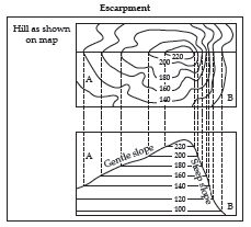
➢ Escarpment : It is a landform with sides sloping in opposite directions. It is a steep slope on one side and a gentle slope on the other side. The steep slope is called a scarp and the gentle slope is called a dip slope. A scarp has closely spaced contours while a dip slope has widely spaced contours
➢ A Ridge : It is a long elongated chain of hills with two or more summits.
➢ A Col : A col is a narrow, high pass through a mountain chain formed by the meeting of river or glacier valley from opposite sides of the range.
➢ A Saddle : It is a pass that slopes gently between two peaks and is shaped like a horse saddle. It is broader than a col.

➢ The scale of a map is the proportion between the distance on the map and the corresponding distance on the ground. There are three ways of expressing scale-
(i) The Statement of Scale : It expresses the relationship of map to the ground in words e.g. two centimeters to 1 kilometer and is expressed as 2cm=1km.
(ii) The Representative Fraction (R.F.) : It is the ratio between the distance on the map to the distance on the corresponding ground and is in fraction. The numerator denotes the length on the map and the denominator denotes the actual distance on the ground. e.g. 1:50,000.
(iii) The Linear or Graphical Scale : It is divided into primary and secondary divisions. It is 10 to 20 centimeters long which is divided into 8 divisions of two centimetres each representing one kilometre each from 1 to 7 kilometres.
➢ There are various methods to measure distances in a map such of them are :
(i) to measure distance along a straight line,
(ii) to measure distance along curves and
(iii) area by the grid square method.
➢ There are four main cardinal directions- North, South, East and West.
➢ These directions are further divided into four major directions-North-East, North-West, South-East and South-West.

➢ The North to which the compass needle points is called Magnetic North.
➢ The Magnetic Compass is an instrument which is used in finding directions.
➢ Bearing is the horizontal angle between the direction of an object and the clockwise direction from North.
➢ A bearing with reference to magnetic north-south line is called Magnetic Bearing.
➢ A bearing measured with reference to geographic north-south line is called True Bearing.
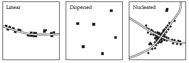
➢ Settlement means a cluster of inhabited houses- urban and rural.
➢ There are different patterns of settlements like- Nucleated or clustered, dispersed or scattered, linear, radial and rectangular pattern of settlements
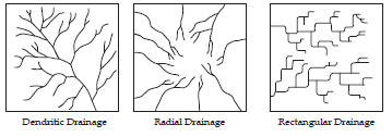
➢ The various patterns of drainage formed due to the development of streams and rivers known as drainage patterns.
➢ There are different drainage patterns. They are Dendritic, Trellis or Rectangular, Radial, Disappearing or Irregular drainage patterns
➢ The Height that is represented by a triangle (Δ) beside a number which indicates its height above mean sea level, like Δ 364 is called Triangulated Height. It is more accurate than Spot Height because it is calculated by trigonometry.
➢ Spot Height is represented on the map by a black dot in front of the number like, .275, which indicates the height of that particular point above mean sea level.
➢ Surveyors make a permanent cut or mark on a rock, stone, prominent building or place called the Bench Mark (B.M.). It indicates the height of that place above mean sea level.
➢ Relative Height/Depth is represented by a small ‘r’ written along with a number, like, 22r. It indicates the relative height or depth of a particular point from the surrounding surface and not from the sea level. It is marked beside the well, tank, embankment, peak, dam, sand dune, bank of a river, etc.
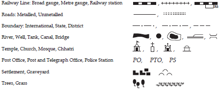
➢ The Topographical map uses signs and symbols to represent certain man made and physical features. These are called Conventional Signs and Symbols.
➢ Causeway : A raised road over a small stream but not a bridge/ A raised metalled road over a non-perennial stream or marshy area or which serves as a temporary bridge.
Know the terms
➢ Topographic map : It is a detailed and accurate graphic representation of cultural and natural features on the ground.
➢ Grid Reference : It helps in finding the exact location of a place on a map through a set of lines called the Eastings and the Northings.
➢ Coordinates : The points at which the vertical and the horizontal lines of grid crosses.
➢ Conical Hill : It is a landform having a summit at a high elevation. It is shown by closed contours almost circular in shape.
➢ Scale : It is the proportion between the distance on the map and the corresponding distance on the ground.
➢ Cardinal Directions : One of the four principal directions on a compass: north, south, east, or west.
➢ Settlement : It means a cluster of inhabited houses- urban and rural.
➢ Drainage Patterns : The various patterns of drainage formed due to the development of streams and rivers.
➢ Triangulated Height : The Height that is represented by a triangle (Δ) beside a number which indicates its height above mean sea level, like Δ 364.
➢ Bench Mark (B.M.) : Surveyors make a permanent cut or mark on a rock, stone, prominent building or place.
➢ Relative Height/Depth : It is represented by a small ‘r’ written along with a number, like, 22r. It indicates the relative height or depth of a particular point from the surrounding surface and not from the sea level.

We hope you liked Interpretation of Topo Graphical Maps ICSE Class 10 Geography notes above. If you have any questions please post them in the comments section below and our teachers will provide you a response.

