Students should refer to Location, Extent and Physical Features ICSE Class 10 Geography notes provided below designed based on the latest syllabus and examination pattern issued by ICSE. These revision notes are really useful and will help you to learn all the important and difficult topics. These notes will also be very useful if you use them to revise just before your Geography Exams. Refer to more ICSE Class 10 Geography Notes for better preparation.
ICSE Class 10 Geography Location, Extent and Physical Features Revision Notes
Students can refer to the quick revision notes prepared for Chapter Location, Extent and Physical Features in Class 10 ICSE. These notes will be really helpful for the students giving the Geography exam in ICSE Class 10. Our teachers have prepared these concept notes based on the latest ICSE syllabus and ICSE books issued for the current academic year. Please refer to Chapter wise notes for ICSE Class 10 Geography provided on our website.
Location, Extent and Physical Features ICSE Class 10 Geography
Location, Extent and Physical Features ICSE Class 10 Geography Notes
Quick Review
➢ India is a land of unity in diversity since it has diverse language, religion, castes and creeds.
➢ It is the second most populous country in the world and the seventh largest in size.
➢ India extends from 8°4’ N to 37°6’ N and from 68°7’ E to 97°25’ E.
➢ India can be divided into five ethnic groups- Proto-Australoids, Negritos, Mongoloids, Mediterraneans or Dravidians and Nordic Aryans.
➢ Officially, 22 languages out of 200 languages spoken in India, has been recognised in the Eighth Schedule of the Constitution of India.
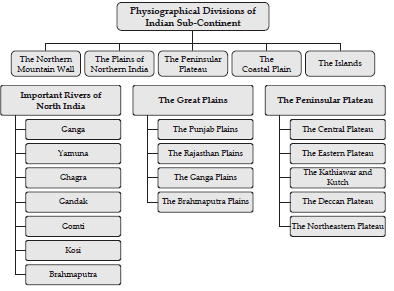
➢ The Indian Sub-continent has been divided into five physiographical divisions-
(i) The Northern Mountain Wall
(ii) The Plains of Northern India
(iii) The Peninsular Plateau
(iv) The Coastal Plains
(v) The Islands.
➢ The Northern mountain wall is also known as the Himalayan Range. It consist of three parallel ranges- the Himadri, the Himachal and the Shiwalik Range.
➢ The Himadri is also called the Great Himalayas or the Inner Himalayas. The Himachal is also known as the Himachal-Himalayas or the Middle or Lesser Himalayas and the Shiwalik range is also called the Outer Himalayas.
➢ The Great Himalayas has the world’s highest peak, Mt. Everest (8,848 m) and the world’s second highest peak, Mount K2 or Godwin Austen.
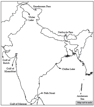
➢ It has many passes, namely, Karakoram Pass, Shipki-La Pass, Mana Pass, Niti, etc.
➢ The Himachal range runs parallel to the Himadri. Doons lie between the Himachal and the Shiwalik ranges e.g. Dehradun.
➢ Some the most important hill stations lie in this range, e.g. Mussorie, Shimla, Nainital, Almora, Ranikhet, Chail, etc.
➢ The Shiwalik range is not a continuous range and its average elevation is about 1000 m above sea level.
➢ The Doon, Bhabhar, Terai and the Khadar and Bhangar alluvium are the other important features of the Himalayas.
➢ The Himalayas act as a climate-divide since it protect northern India from severe cold in winters and act as barrier for the moisture-laden monsoon winds which bring heavy rain to the north Indian plains.
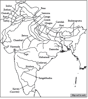
➢ The Himalayas are a source of many perennial rivers due to the glaciers over there. Rivers like Ganga, Yamuna, Ghagra, Gandak, Gomti, Kosi, Sharda and Brahmaputra provide water for drinking and irrigation to the entire Northern plains.
➢ The rivers originating in the Himalayas are a major source of hydel power.
➢ The Himalayas act as a physical barrier to the invaders.
➢ It attracts thousands of tourists from India and abroad due to the large number of hill stations like, Mussorie, Nainital, Shimla, Srinagar, Ranikhet, etc. and pilgrimage centres like the shrines of Badrinath, Kedarnath, Amarnath, Vaishno Devi, Kailash-Mansarovar, etc.
➢ The Himalayas also attract the adventure seekers as it provides a lot of opportunities for trekking, hiking, river rafting, skiing, etc.
➢ The Himalayas are rich in forest resources as it provides both hard wood and soft wood and is also a home to a wide variety of wild animals like yaks, bears, tigers, elephants, red pandas, snow leopard, etc.
➢ It is a store house of minerals like copper, lead, nickel, cobalt, tungsten, coal and also gold, silver and precious stones.
➢ The rivers flowing down from the Himalayas through the northern plains carry alluvium and deposits in the flood plain which is very fertile.
➢ The plains of Northern India have three major rivers- Indus, Ganga and Brahmaputra along with their tributaries.
➢ The River Ganga rises in the Gangotri glacier in the Himalayas, the river Indus has its source in the Kailash range and the Brahmaputra River rises in Tibet near Lake Mansarovar.
➢ The Great Plains can be sub-divided into the following areas-
(i) The Punjab Plains
(ii) The Rajasthan Plains
(iii) The Ganga plains
(iv) The Brahmaputra Plains
➢ The Northern Plains are of great significance because of the following reasons-
(i) Due to the presence of a good network of rivers and favourable climate, these plains support dense population.
(ii) The fertile soil, perennial rivers and favourable climate have made the northern plains excellent agricultural land.
(iii) Large number of multi-purpose dams has been constructed across the rivers to provide water for irrigation and to generate electricity.
(iv) Socially and religiously, the northern plains are of great significance. Many religious and historical cities like Allahabad, Varanasi, Haridwar, Mathura, etc. are situated along the rivers.
(v) Due to the flat level surface of the northern plains, construction of a network of roads and railways are possible. The rivers are also navigable and allow comfortable transportation. It also facilitates easy access to good communication system.
➢ The Peninsular Plateau is the largest and the oldest of all the physiographical divisions.
➢ It has an elevation of 600 m to 900 m and is a stable terrain due to the lava tract which was formed due to the volcanic eruptions.
➢ The plateau can be divided into the following-
(i) The Central Plateau
(ii) The Eastern Plateau
(iii) The Kathiawar and Kutch
(iv) The Deccan Plateau
(v) The Northeastern Plateau
➢ The Western Ghats, the Eastern Ghats, the Vindhya range, the Satpura range and the Aravalli Hills are the mountains of the Peninsular India.
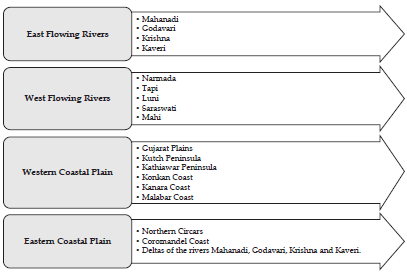
➢ The major Peninsular Rivers are divided into- The East flowing rivers and the West flowing rivers.
➢ The East flowing rivers are- the Mahanadi, the Godavari, the Krishna, the Cauvery or Kaveri.
➢ The West flowing rivers are- the Narmada, the Tapti, the Luni, the Sabarmati and the Mahi.
➢ The rivers of Northern India differs from the rivers of Peninsular India in the following way-

➢ The Deccan Plateau is flanked by two coastal plains on either side of it- The Western Coastal Plains and the Eastern Coastal Plains.
➢ The Western Coastal Plains consists of- the Gujarat Plains, the Kutch Peninsula, the Kathiawar Peninsula, the Konkan Coast, the Kanara Coast and the Malabar Coast.
➢ The Eastern Coastal Plains consists of- the Northern Circars and the Coromandel Coast and has prominent deltas of the rivers Mahanadi, Godavari, Krishna and Cauvery or Kaveri.
➢ These coastal plains also include several lakes like Chilka Lake in Odisha and Kolleru and Pulicat lakes in Andhra Pradesh.
➢ Coastal Plains are quite significant because of the following reasons-
(i) They are the source of precious minerals.
(ii) The Kerala coast has large quantities of Monazite which is used for nuclear power.
(iii) The sedimentary rocks of these coastal plains have large deposits of mineral oil.
(iv) The ports accounts for 98% of the international trade.
(v) Fisheries are an important activity in these coastal plains.
➢ India has two groups of islands- the Andaman and Nicobar Islands in the Bay of Bengal and the Lakshadweep Islands in the Arabian Sea.
➢ The Andaman and Nicobar Islands are a group of 300 islands.
➢ The two groups of islands are separated by the Ten Degree Channel.
➢ The chief islands are- Great Nicobar and Car Nicobar.
➢ The Lakshadweep islands consist of 36 islands.
➢ The northern portion of the island is called the Amindivis and the remaining island is called the Laccadives.
Know the terms
➢ Pass : It is a route through a mountain range or over a ridge.
➢ Doon : Doons were originally temporary lakes but due to the upliftment of the Himalayas, rivers carved out their own courses and the lakes dried up and turned into valleys.
➢ Bhabhar : Theseare porous, gravel-ridden plains at the foot of the Himalayas.
➢ Terai- It is a marshy underground seepage area formed when water from the Bhabhar areas seep down in the soil and suddenly appear.
➢ Khadar and Bhangar : The new alluvium brought down by the rivers in low lying zones is the Khadar soil and the old alluvium soil found in the riverbeds above the flood plain level is known as Bhangar.
➢ Perennial river : The rivers which flow throughout the year due to the continuous melting of snow.
➢ Flood Plain : It is a generally flat area of land next to a river or stream. It is made up of sediments such as sand, silt, and clay deposited during floods.
➢ Multi-purpose Dams : Huge dams that are built to serve many purposes like irrigation, generating electricity, fishing, recreation centres, etc.
➢ Peninsular Plateau : It is the oldest landmass made up of lava flows and is composed of the old crystalline, metamorphic and igneous rocks.
➢ Erode : To wear away of soil, rock or land with gradual destruction by natural forces such as water, wind, or ice.
➢ Delta : A river delta is a landform that forms from deposition of sediment carried by a river.
➢ Ten Degree Channel : The Ten Degree Channel is a channel that separates the Little Andaman and Car Nicobar in the Bay of Bengal.
Flowcharts
Map of India
On the Outline Map of India, candidates will be required to locate, mark and name the following:
➢ Mountains, Peaks and Plateaus : Himalayas, Karakoram, Aravalli, Vindhyas, Satpura, Western and Eastern Ghats, Nilgiris, Garo, Khasi, Jaintia, Mount Godwin Austin (K2), Mount Kanchenjunga. Deccan Plateau and Chotanagpur Plateau.
➢ Plains : Gangetic Plains and Coastal Plains- Konkan, Kanara, Malabar, Coromandel, Northern Circars.
➢Desert : Thar (The Great Indian Desert).
➢ Rivers : Indus, Ravi, Beas, Chenab, Jhelum, Satluj, Ganga, Yamuna, Ghagra, Gomti, Gandak, Kosi, Chambal, Betwa Son, Damodar, Brahmaputra, Narmada, Tapti, Mahanadi, Godavari, Krishna, Cauveri and Tungabhadra.
➢ Water Bodies : Gulf of Kutch, Gulf of Khambhat, Gulf of Mannar, Palk Strait, Andaman Sea, Chilka Lake, Wular Lake.
➢ Passes : Karakoram and Nathu-La Passes.
➢ Latitudes and Longitudes : Tropic of Cancer, Standard Meridian (82°30’E).
➢ Directions of Winds : South West Monsoons (Arabian Sea and Bay of Bengal Branches), North East Monsoon and Western Disturbances.
➢ Distribution of Minerals : Oil- Mumbai High (Offshore Oil Field) and Digboi. Iron- Singhbhum, Coal- Jharia.
➢ Soil Distribution : Alluvial, Black, Laterite and Red Soil.
➢ Cities : Delhi, Mumbai, Kolkata, Chennai, Hyderabad, Bengaluru, Kochi, Chandigarh, Srinagar, Vishakhapatnam, Allahabad.
➢ Population : Distribution of Population (Dense and Sparse).
1. The Mountain Ranges, Mountain Peaks and Hill Ranges of India :

2. The Plain (The Northern Plains and Coastal Plains) and Plateau Regions of India :

3. The Major Rivers of India :
4. Important Passes, Lakes and Gulfs of India
5. Monsoon Winds and Important Latitude and Longitude of India :

6. Iron-ore Mines, Oilfields, Coalfields and different population density zones in India :

7. Major Soils in India :

8.Major software parks in India :


We hope you liked Location, Extent and Physical Features ICSE Class 10 Geography notes above. If you have any questions please post them in the comments section below and our teachers will provide you a response.