Students of ICSE Class 10 should refer to Location Extent And Physical Features ICSE Class 10 Geography previous year questions and solutions. below which have come in past board exams. You should always go through questions that have come in previous years. This will help you to understand the pattern of questions in ICSE Class 10 Geography and prepare accordingly. This will help you to get better marks in ICSE Class 10 Board Exams
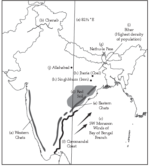
Question: On the outline map of India provided:
(a) Eastern Ghats and Western Ghats
(b) River Chenab
(c) Mark with arrow, the direction of the Bay of Bengal branch of South West monsoon.
(d) Shade and name an area where red soil is found extensively.
(e) The Longitude 82½°E
(f) Coromandel Coast
(g) Nathu-La Pass [1]
(h) Mark and label the leading states for coal and iron ore.
(i) Shade and name the state with highest density of population.
(j) Mark with a red dot and name Allahabad.
Answer:
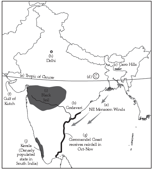
Question: On the outline map of India provided:
(a) Draw and name the Tropic of Cancer.
(b) Label the river Godavari.
(c) Mark and name the Garo Hills.
(d) Mark C on the coal fields of Jharia.
(e) Mark with an arrow and name the NE monsoon over the Bay of Bengal.
(f) Shade and name the Gulf of Kutch.
(g) Shade and name the coastal plain that receives rainfall in October-November.
(h) Mark with a dot and name Delhi.
(i) Shade a region with Black Cotton Soil.
(j) Use an arrow to point at a densely populated state in South India.
Answer:
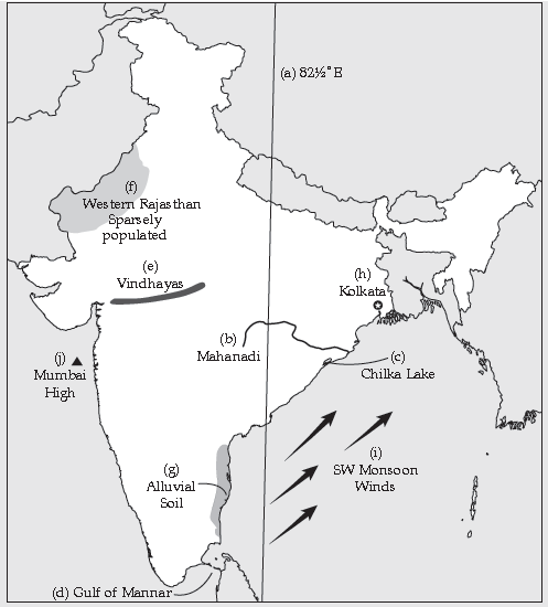
Question: On the outline map of India provided:
(a) Draw and number the Standard Meridian of India.
(b) Label the river Mahanadi.
(c) Mark and name Lake Chilka.
(d) Shade and name the Gulf of Mannar.
(e) Mark and name the Vindhya Mountains.
(f) Shade and name a sparsely populated region in Western India.
(g) Shade a region with Alluvial Soil in South India.
(h) Mark and name Kolkata.
(i) Mark with arrows and name South West Monsoon winds over the Bay of Bengal.
(j) Mark and name Mumbai High.
Answer:
Question: On the outline map of India provided:
(a) Mark and name the Nilgiris.
(b) Shade and label the Malwa Plateau.
(c) Shade and label the Malabar Coastal Plains.
(d) Mark and name the river Gomti.
(e) Shade and name the Andaman Sea.
(f) Mark and name Allahabad.
(g) Mark with a single arrow and name the winds that bring winter rain to north-west India.
(h) Mark and name Digboi.
(i) Mark an area with Laterite soil below the Tropic of Cancer.
(j) Mark and name the Karakoram Pass.
Answer:

Question: On the outline map of India provided:
(a) Draw, name and number the Standard Meridian.
(b) Label the river Yamuna.
(c) Shade and name the Gulf of Khambhat.
(d) Mark and name the Nathu-La Pass.
(e) Mark and name the Karakoram Range.
(f) Shade and name a sparsely populated state in Northeast India.
(g) Shade a region with Laterite soil in Eastern India.
(h) Mark with a dot and name Vishakhapatnam.
(i) Mark and name the winds that bring rain to West Bengal in summer.
(j) Print S on the iron mines in Singhbhum.
Answer:

Question: On the outline map of India provided:
(a) Mark and name Chennai.
(b) Label the river Godavari.
(c) Shade and label the Chota Nagpur Plateau.
(d) Shade and name the Gulf of Kutch.
(e) Mark and name the Indo-Gangetic Plains.
(f) Shade and label an area with Red soil.
(g) Mark and name the winds which bring rain to Mumbai in July and August.
(h) Mark and name the Satpura Range.
(i) Mark and name the Jharia Coal Field.
(j) Shade and label the Northern Circar coastal region.
Answer:

Question: On the outline map of India provided:
(a) Draw, name and number the Tropic of Cancer.
(b) Label the river Narmada.
(c) Shade and name Lake Chilka.
(d) Mark and name the Aravalli Mountains.
(e) Mark and name the Karakoram Pass.
(f) Shade and name a densely populated state in South India.
(g) Shade and name a region with Black soil
(h) Mark with a dot and name Srinagar.
(i) Mark and name the winds which bring rain in winter to the Coromandel Coast.
(j) Name and print O on an oilfield in North-east India.
Answer:

Question: On the outline map of India provided:
(a) Mark and name Kochi.
(b) Label the river Krishna.
(c) Shade and label the Malwa Plateau.
(d) Mark and label the Konkan Coast.
(e) Shade and label the Gulf of Mannar.
(f) Shade and label an alluvial soil area in Peninsular India.
(g) Mark with arrows the direction of the Arabian Sea branch of South West Monsoon Winds.
(h) Shade and label the Western Ghats.
(i) Mark the Jharia coalfield.
(j) Shade and name a densely populated area.
Answer:

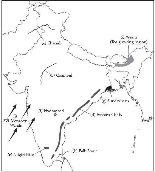
Question: On the outline map of India provided:
(a) Label the river Chenab,
(b) Label the river Chambal.
(c) Shade and label the Nilgiri Hills.
(d) Mark and label the Eastern Ghats.
(e) Mark and name the port city of Pakistan.
(f) Mark and label Hyderabad.
(g) Shade and label the Sunderbans.
(h) Mark and name the Palk Strait.
(i) Mark and label a region North of the Tropic of Cancer where Tea is grown extensively.
(j) Mark and name the winds which bring rain to Mumbai in July and August.
Answer:
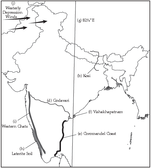
Question: On the outline map of India provided:
(a) Mark and name Dhaka.*
(b) Label the river Kosi.
(c) Shade and label the Shiwalik Range*
(d) Label the River Godavari.
(e) Mark and label the Coromandel Coast.
(f) Mark and label Vishakhapatnam.
(g) Mark and label the 82½°E Meridian.
(h) Shade and label an area of laterite soil in Peninsular India.
(i) Mark with a bold line and name the Western Ghats.
(j) Mark with arrows the direction of the Westerly depression winds.
Answer:

Question: On the outline map of India provided:
(a) Label the river Satluj.
(b) Label the river Godavari.
(c) Mark with a bold line and name the Aravalli Range.
(d) Mark and label the Khyber Pass.*
(e) Mark and name the largest commercial city of Pakistan.*
(f) Mark and label Bangalore (Bangluru).
(g) Shade and label an area of laterite soil in North Eastern India.
(h) Mark and name an offshore oilfield.
(i) Mark and label the Tropic of Cancer.
(j) Mark and name the winds which bring rain to Bangladesh in July and August.*
Question: On the outline map of India provided:
(a) Shade and label the country Nepal.*
(b) Shade and label an area of black soil in India.
(c) Mark and label the Konkan Coast.
(d) Shade and label one region of winter rainfall in India.
(e) Shade and label the Sulaiman Range.*
(f) Label the River Yamuna.
(g) Mark and name the port city of Bangladesh.*
(h) Label the River Tapti.
(i) Shade and label the Vindhya Ranges.
Answer:

Question: On the outline map of India provided:
(a) Shade and label the Satpura Range.
(b) Label the River Krishna.
(c) Mark and name the capital city of Pakistan.*
(d) Label the river Ravi.
(e) Shade and label the Khasi Hills.
(f) Mark with arrows the direction of the North East Monsoon winds over the Bay of Bengal.
(g) Mark and label the Malabar Coast.
(h) Shade and label an area of Laterite soil in India.
Answer:

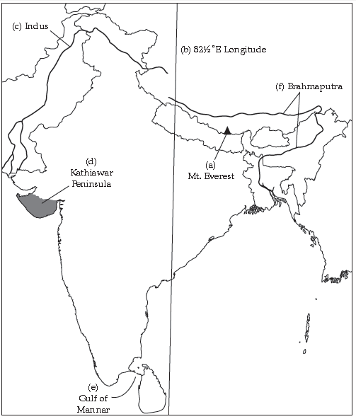
Question: On the outline map of India provided to you, mark and label the following :
(a) Mount Everest.
(b) 82½°E Longitude.
(c) River Indus.
(d) Kathiawar Peninsula.
(e) Gulf of Mannar.
(f) River Brahmaputra.
(g) The Capital of Nepal.*
(h) Dhaka.*
(i) An important port of Pakistan.*
(j) Direction of the Summer Monsoon over Sri Lanka.*
Answer:
Question: On the outline map of the Indian Sub-Continent provided to you at the end of this question paper:
(a) Mark and label:
(i) The Sulaiman Ranges*
(ii) Western Ghats
(iii) Bolan Pass.*
(b) Shade and name one region for each of the following:
(i) Thorn and Scrub Vegetation in India.*
(ii) Wheat cultivation in Pakistan.*
(iii) Coffee cultivation in South India.*
(c) Shade and Label:
(i) A region of Red soil in India
(ii) The Thar Desert
(iii) One region in India that gets winter rainfall.
(d) Identify and name:
(i) The capital city of Bangladesh*
(ii) River Yamuna
(iii) The port city of Pakistan*
Answer:

Question: On the outline map of the Indian Sub-Continent provided to you at the end of this question paper:
(a) Mark with a bold line and label:
(i) The Karakoram Range
(ii) The Eastern Ghats
(iii) The Nilgiris.
(b) Shade and name one region for each of the following:
(i) Desert Vegetation*
(ii) Black soil
(iii) Tobacco cultivation.*
(c) Mark and label:
(i) The Khyber Pass*
(ii) The capital city of Assam*
(iii) River Godavari.
(d) (i) Identify, shade and name:
(1) A region of sparse population (less than 50 pp. sq.) in North Eastern India.
(2) A region of ‘Equatorial Forests’.*
(ii) Mark with one long arrow, the direction of the Summer Monsoon over the Bay of Bengal.
Answer:


