Students can refer to the following Sample Paper ICSE Class 10 Geography Set F with Answers provided below based on the latest syllabus and examination guidelines issued for ICSE Geography. All specimen papers have been prepared covering all chapters given in ICSE Geography book for Class 10. You should also refer to ICSE Class 10 Geography Solutions.
Sample Paper ICSE Class 10 Geography Set F with Answers
Subject: Geography (Paper II)
Answer to this paper must be written on the paper provided separately.
You will not be allowed to write during the first 15 minutes.
This time is to be spent in reading the question paper.
The time given at the head of this paper is the time allowed for writing the answers.
Attempt seven questions in all.
Part I is compulsory. All questions from Part 1 are to be attempted.
A total of five questions are to be attempted from part II.
The intended marks for the questions or parts of questions are given in brackets ( ).
PART I [30 MARKS]
Attempt all questions from this Part.
Question 1
Study the extract of the Survey of India Map sheet No. 45D/10 and answer, the question that follow (2017):
a. Give the six figure grid reference of (2)
i. Spot height 361
ii. Temple in Marol
b. Calculate the (2)
i. Indirect distance between causeway near Palri Khera to temple in Karaunti in Kms.
ii. The area between eastings 07 to 12 and nothings 03 to 06.
c. What are the three different types of scales? Which scale is said to be universally accepted? (2)
d. What do the following indicate? (2)
i. Motorable in dry season.
ii. LY in grid square 0201
e. Identify the drainage pattern in: (2)
i. 0705
ii. 0808
f. Identify the settlement pattern in the following grids: (2)
i. Pipliya in 1005
ii. Was in 1007
g. Identify the relief feature in: (2)
i. 1110
ii. 0905
h. Give the direction of the following: (2)
i. Sukli Nadi, support your answer with a reason,
ii. Dolpura to Makawal
i. Mention two occupations of the people living in Pipliya (0906). (2)
j. Mention two man-made and two natural features in grid squate 0410. (2)
Question 2
On the outline map of India provided mark and label the following: (10)
a. Chota Nagpur Plateau
b. Mount Godwin Austin
c. Mount Kanchenjunga
d. Vindhya Range
e. Nilgiris
f. Konkan coast
g. River Tapti
h. Chilka Lake
i. Winds that bring rain to the eastern coastal plains in winter
j. Name and mark an area of an off-shore petroleum reserve
PART II [50 MARKS]
Attempt any five questions from this Part.
Question 3
a. Mention the four principal seasons on the basis of monsoon variations. (2)
b. Mention the local winds in the following areas and state any one of its economic advantage.(2)
i. Assam
ii. Kerala
c. Mention the factors that determine the distribution of rainfall. (3)
d. Study the climactic data given below and answer the questions that follow:
i. Calculate the mean annual temperature.
ii. What is the total rainfall during the monsoon season?
iii. Does the station have a maritime or a continental climate? Give reason for your answer.
Question 4
a. i. Name two types of laterite soil. (1)
ii. Why is alluvial soil said to be loamy? (1)
b. Define the following: (2)
i. Gully erosion
ii. Leaching
c. To counter the vicious cycle of poverty and soil erosion what do the government agencies need to encourage?(3)
d. i. Name the minerals present in alluvial soil. (1)
ii. Name the minerals lacking in black soil. (1)
iii. Name two crops grown in red soil. (1)
Question 5
a. Mention two characteristics of Montane forests. (2)
b. Mention four effects of the decline of forest cover. (2)
c. Name the following trees: (3)
i. Leaves are used for rearing shellac worms.
ii. Is a fruit tree. Fruits of which is eaten raw or made into pickles.
iii. Bark and roots have medicinal priorities. It is effective in treating diabetes,
allergies, ulcers and several other diseases.
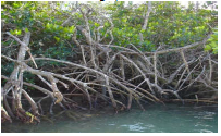
d. With reference to the given picture, answer the following questions: (3)
i. Name the type of forests where these trees are found.
ii. Mention two characteristics of these types of tree.
iii. Mention two uses of these trees.
Question 6
a. State two conditions required for digging a surface well? State one reason for its popularity among farmers. (2)
b. Explain the following terms: (2)
i. Aquifer
ii. Sprinkler irrigation
c. Give reasons for the following: (3)
i. The conventional irrigation systems suffer from a number of constraints leading to Improper utilization of water.
ii. Tank irrigation is not a dependable source of irrigation.
iii. Nature of the soil is a determining factor of the type of irrigation to be put into practice.
d. Name the states that benefit from the given canals: (3)
i. Bhakra canal
ii. Indira Gandhi canal
iii. Vishweshwaraya canal
Question 7
a. i. What are minerals? (1)
ii. Mention any two characteristics of minerals. (1)
b. What is tidal energy? State its two advantages. (2)
c. Give geographical reasons for the following: (3)
i. Natural gas deposits mainly accompany oil deposits.
ii. Manganese is essential for plant growth.
iii. Copper is used to make electric wires.
d. Explain the process of Nuclear Energy generation. What are the two types of nuclear reactors?(3)
Question 8
a. Mention any two features of plantation farming. Name a state where it is practiced the most.(2)
b. Why do pulses form an important part of the Indian diet? Name 2 important pulses grown in India.(2)
c. ‘Cotton is a cash crop that supplies raw materials to our textile industry’. In light of the above statement answer the following questions:(3)
i. What type of soil is needed for cotton cultivation?
ii. Mention the temperature and rainfall required to grow cotton.
iii. When is cotton seeds planted and when is it harvested? State reasons for your answer.
d. Explain the harvesting and processing of jute. (3)
Questions 9
a. Name any two geographical factors and any two commercial factors that affect location of industries.(2)
b. Explain the following terms and give one example for each: (2)
i. Tertiary industries
ii. Ancillary industries
c. State three problems faced by iron and steel industries. (3)
d. With reference to Electronic industries answer the following questions: (3)
i. When did it develop in India?
ii. ‘It began with radio manufacturing and later diversified into many areas,’ name two such areas.
iii. What is the main requirement of such an industry?
Question 10
a. State two reasons why peninsula rivers are not navigable. (2)
b. State two disadvantages of roadways. (2)
c. What is the role played by transportation in India? (3)
d. With reference to Kandla port answer the following questions: (3)
i. Where is it located?
ii. What type of a port is it?
iii. Name two products which are exported from his port.
Question 11
a. Distinguish between toxic waste and non-toxic waste. (2)
b. How are plants affected by waste accumulation? (2)
c. What is global warming? State two effects of global warming. State the causes of Ozone layer depletion. Name the layer of atmosphere which has the maximum concentration of ozone. (3)
d. With reference to biomagnifications answer the following questions: (3)
i. What is biomagnifications?
ii. What is the cause of biomagnifications?
iii. How does it effect us?
